IMAGES TAKEN NEAR TO
Colston Road, NOTTINGHAM, NG12 3BN
Introduction
This page details the photographs taken nearby to Colston Road, NG12 3BN by members of the Geograph project.
The Geograph project started in 2005 with the aim of publishing, organising and preserving representative images for every square kilometre of Great Britain, Ireland and the Isle of Man.

There are currently over 7.5m images from over14,400 individuals and you can help contribute to the project by visiting https://www.geograph.org.uk
Image Map
Images are licensed for reuse under creativecommons.org/licenses/by-sa/2.0
Notes
- Clicking on the map will re-center to the selected point.
- The higher the marker number, the further away the image location is from the centre of the postcode.
Image Listing (6 Images Found)
Images are licensed for reuse under creativecommons.org/licenses/by-sa/2.0
Image
Details
Distance
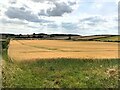
1
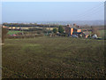
Groundwells Farm
Looking down from the edge of Cropwell Wolds.
Image: © Alan Murray-Rust
Taken: 13 Nov 2011
0.02 miles
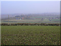
2
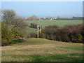
View from Cropwell Wolds
Looking towards Cropwell Bishop.
Image: © Alan Murray-Rust
Taken: 13 Nov 2011
0.12 miles
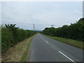
5
Rolling Farmland and Fields
Looking in the direction of Owthorpe.
Image: © Jonathan Clitheroe
Taken: 3 Aug 2024
0.18 miles
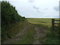
6
View from Cropwell Wolds
Looking east to Blue Hill.
Image: © Alan Murray-Rust
Taken: 13 Nov 2011
0.21 miles