IMAGES TAKEN NEAR TO
Nottingham Road, NOTTINGHAM, NG12 3BA
Introduction
This page details the photographs taken nearby to Nottingham Road, NG12 3BA by members of the Geograph project.
The Geograph project started in 2005 with the aim of publishing, organising and preserving representative images for every square kilometre of Great Britain, Ireland and the Isle of Man.

There are currently over 7.5m images from over14,400 individuals and you can help contribute to the project by visiting https://www.geograph.org.uk
Image Map
Images are licensed for reuse under creativecommons.org/licenses/by-sa/2.0
Notes
- Clicking on the map will re-center to the selected point.
- The higher the marker number, the further away the image location is from the centre of the postcode.
Image Listing (57 Images Found)
Images are licensed for reuse under creativecommons.org/licenses/by-sa/2.0
Image
Details
Distance
1
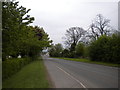
Entering Cropwell Bishop from the west
Looking along Nottingham Road towards Cropwell Bishop. The 30mph speed limit signs give an approximate indication of the point at which the village nominally begins.
Image: © Richard Vince
Taken: 18 May 2013
0.01 miles
2
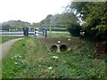
Cropwell Town Bridge on the Grantham Canal
Bridge #21 on the canal which runs for 33 miles between Grantham and the River Trent at West Bridgford. The canal, which opened in 1797 and was abandoned in 1936, is now mostly derelict. Many of the original road bridges have been demolished and replaced with flat crossings such as this. Since the 1970s, the Grantham Canal Society have been working towards restoring the canal, and two stretches are now navigable. Full restoration, however, is unlikely as it would require the rebuilding of several of these road bridges.
Image: © Graham Hogg
Taken: 11 Oct 2016
0.01 miles
3
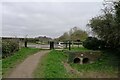
Nottingham Road crossing the Grantham Canal at Cropwell Town Bridge
The Grantham Canal Society has ambitious plans to restore parts of the canal to navigation http://www.granthamcanal.org/#. But some obstacles may make this impossible at the western end.
Image: © Tim Heaton
Taken: 22 Mar 2021
0.02 miles
4

Cropwell Bridge, Cropwell Bishop, Notts.
The village of Cropwell Bishop can be reached within minutes by following Nottingham Road to the right. The footpath ahead links this bridge with Berry Hill and Hoe Hill.
Image: © David Hallam-Jones
Taken: 11 Jan 2014
0.02 miles
5
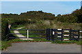
Footpath gateway, Cropwell Bishop
The gateway allows access to the footpath that was once the towpath of the Grantham Canal (closed 1929) as it heads south from Nottingham Road, on the western edge of Cropwell Bishop.
Image: © Richard Vince
Taken: 18 May 2013
0.02 miles
6
Nottingham Road Bridge No 21 along the Grantham Canal
Image: © Mat Fascione
Taken: 6 Oct 2013
0.02 miles
7
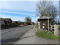
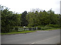
Nottingham Road, Cropwell Bishop
Bus shelter, public bridleway signpost, by the playground.
Image: © Peter Barr
Taken: 7 Feb 2013
0.03 miles
8
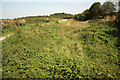
Grantham Canal
Disused and overgrown Grantham Canal from Cropwell Bridge
Image: © Richard Croft
Taken: 3 Sep 2012
0.03 miles
9

Cropwell Bridge, Cropwell Bishop, Notts.
The footpath ahead links this bridge - Cropwell Bridge - with Berry Hill and Hoe Hill. The village of Cropwell Bishop can be reached within minutes by following Nottingham Road, to the photographer's right.
Image: © David Hallam-Jones
Taken: 11 Jan 2014
0.03 miles
10
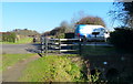
Nottingham Road Bridge No 21
Crossing the disused Grantham Canal at Cropwell Bishop.
Image: © Mat Fascione
Taken: 24 Nov 2017
0.03 miles