IMAGES TAKEN NEAR TO
Grange Park, NOTTINGHAM, NG12 3AW
Introduction
This page details the photographs taken nearby to Grange Park, NG12 3AW by members of the Geograph project.
The Geograph project started in 2005 with the aim of publishing, organising and preserving representative images for every square kilometre of Great Britain, Ireland and the Isle of Man.

There are currently over 7.5m images from over14,400 individuals and you can help contribute to the project by visiting https://www.geograph.org.uk
Image Map
Images are licensed for reuse under creativecommons.org/licenses/by-sa/2.0
Notes
- Clicking on the map will re-center to the selected point.
- The higher the marker number, the further away the image location is from the centre of the postcode.
Image Listing (55 Images Found)
Images are licensed for reuse under creativecommons.org/licenses/by-sa/2.0
Image
Details
Distance
2
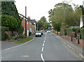
Hardigate Road, Cropwell Butler
Currently the only route out of the village towards Nottingham due to the reconstruction of the A46.
Image: © Alan Murray-Rust
Taken: 2 Sep 2011
0.05 miles
3
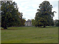
Cropwell Grange
A large detached house of the early 19th century in rendered brick, with surrounding parkland. Listed Grade II. The parkland has clearly been enclosed from the early open fields as there are still significant signs of ridge and furrow cultivation.
Image: © Alan Murray-Rust
Taken: 2 Sep 2011
0.06 miles
4
Cropwell Grange
A large detached house of the early 19th century in rendered brick, with surrounding parkland. Listed Grade II. The parkland has clearly been enclosed from the early open fields as there are still significant signs of ridge and furrow cultivation.
Image: © Alan Murray-Rust
Taken: 2 Sep 2011
0.06 miles
5
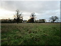
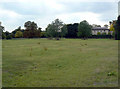
Grass field and Cropwell Grange
Cropwell Grange dates from the early nineteenth century https://historicengland.org.uk/listing/the-list/list-entry/1045657?section=official-list-entry
Image: © Jonathan Thacker
Taken: 3 Dec 2022
0.06 miles
6
Fingerpost, The Green, Cropwell Butler
Standard Nottinghamshire cast iron post with ring and modern fingers. Rather obscured by vegetation.
Image: © Alan Murray-Rust
Taken: 2 Sep 2011
0.07 miles
7
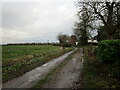
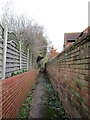
Farm track and footpath, Cropwell Butler
The footpath leads to Bingham and Tithby.
Image: © Jonathan Thacker
Taken: 3 Dec 2022
0.08 miles
8
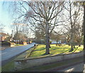
Cropwell Butler, Notts.
As is often the case the village green acts as a focal point. Hardigate Road, with its link to the A46 road, lies behind the photographer and Main Street can be seen ahead, leading towards the next village, Cropwell Bishop. Much of the surrounding land was owned by the Butler family of Warrington - now in Lancashire - hence it was once known as Cropwell Butler This family were Lords of the Manor.
Image: © David Hallam-Jones
Taken: 11 Jan 2014
0.08 miles
9
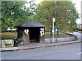
Bus stop, The Green, Cropwell Butler
The shelter is more used as a notice board than the official case alongside.
Image: © Alan Murray-Rust
Taken: 2 Sep 2011
0.08 miles
10
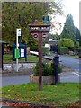
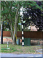
Cropwell Butler civic amenities
Village millennium sign, pump, notice board and bus stop by the village green
Image: © Graham Hogg
Taken: 11 Oct 2016
0.08 miles