IMAGES TAKEN NEAR TO
Fosse Road, NOTTINGHAM, NG12 3AQ
Introduction
This page details the photographs taken nearby to Fosse Road, NG12 3AQ by members of the Geograph project.
The Geograph project started in 2005 with the aim of publishing, organising and preserving representative images for every square kilometre of Great Britain, Ireland and the Isle of Man.

There are currently over 7.5m images from over14,400 individuals and you can help contribute to the project by visiting https://www.geograph.org.uk
Image Map
Images are licensed for reuse under creativecommons.org/licenses/by-sa/2.0
Notes
- Clicking on the map will re-center to the selected point.
- The higher the marker number, the further away the image location is from the centre of the postcode.
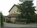
Image Listing (17 Images Found)
Images are licensed for reuse under creativecommons.org/licenses/by-sa/2.0
Image
Details
Distance
1
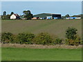
The Limes Farm
Viewed from the disused Grantham Canal.
Image: © Mat Fascione
Taken: 6 Oct 2013
0.02 miles
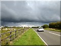
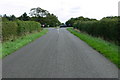
4
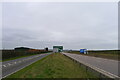
The old and the new A46
The old A46 (left), running on the line of the Roman 'Fosse Way' between Newark and Leicester, was finally replaced by a dual carriageway in 2012.
Image: © Tim Heaton
Taken: 22 Mar 2021
0.05 miles
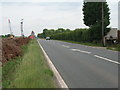
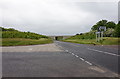
5
The old A46 north of Foss Bridge
The new dual carriageway road is just visible to the left of the photograph.
Image: © Graham Hogg
Taken: 11 Oct 2016
0.13 miles
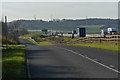
9
Cross Roads
This square is mainly farmland but the A 46 slices across the middle.
Image: © Daniel Robinson
Taken: 30 Aug 2006
0.16 miles
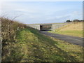
10
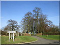
Entrance to the Grove, Cropwell Butler
The footpath sign points to a new footpath which follows the route of the old A46 (Fosse Way).
Image: © Jonathan Thacker
Taken: 3 Feb 2017
0.17 miles