IMAGES TAKEN NEAR TO
Fosse Road, NOTTINGHAM, NG12 3AP
Introduction
This page details the photographs taken nearby to Fosse Road, NG12 3AP by members of the Geograph project.
The Geograph project started in 2005 with the aim of publishing, organising and preserving representative images for every square kilometre of Great Britain, Ireland and the Isle of Man.

There are currently over 7.5m images from over14,400 individuals and you can help contribute to the project by visiting https://www.geograph.org.uk
Image Map
Images are licensed for reuse under creativecommons.org/licenses/by-sa/2.0
Notes
- Clicking on the map will re-center to the selected point.
- The higher the marker number, the further away the image location is from the centre of the postcode.
Image Listing (3 Images Found)
Images are licensed for reuse under creativecommons.org/licenses/by-sa/2.0
Image
Details
Distance
1
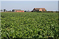
Cropwell Grove Farm
This farm is just off the A46.
Image: © Kate Jewell
Taken: 10 Sep 2006
0.03 miles
2
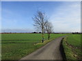
Roadway to Upper Brackendale Farm
This is also a footpath to Cropwell Butler.
Image: © Jonathan Thacker
Taken: 3 Feb 2017
0.24 miles
3
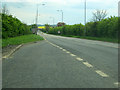
A46 lay-by near Cropwell Grove Farm
Looking south down the A46 to a large yellow rape field in the distance. The Cropwell Butler turn off is just ahead on the left.
Image: © Trevor Rickard
Taken: 1 May 2010
0.24 miles