IMAGES TAKEN NEAR TO
Bloomsbury Mews, NOTTINGHAM, NG12 2NG
Introduction
This page details the photographs taken nearby to Bloomsbury Mews, NG12 2NG by members of the Geograph project.
The Geograph project started in 2005 with the aim of publishing, organising and preserving representative images for every square kilometre of Great Britain, Ireland and the Isle of Man.

There are currently over 7.5m images from over14,400 individuals and you can help contribute to the project by visiting https://www.geograph.org.uk
Image Map
Images are licensed for reuse under creativecommons.org/licenses/by-sa/2.0
Notes
- Clicking on the map will re-center to the selected point.
- The higher the marker number, the further away the image location is from the centre of the postcode.
Image Listing (27 Images Found)
Images are licensed for reuse under creativecommons.org/licenses/by-sa/2.0
Image
Details
Distance
1
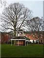
Shelter at Upper Saxondale
The open space, including a number of these shelters, was provided for the benefit of patients when this was Saxondale Hospital.
Image: © Alan Murray-Rust
Taken: 8 Dec 2009
0.03 miles
2
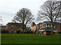
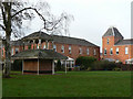
Housing at Upper Saxondale
These are some of the buildings 'inherited' from Saxondale Hospital. The open space was developed for the enjoyment of patients and has been maintained, with several of these fine shelters.
Image: © Alan Murray-Rust
Taken: 8 Dec 2009
0.03 miles
3
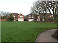
Houses on Buckingham Drive
These are typical of the new-build housing in Upper Saxondale.
Image: © Alan Murray-Rust
Taken: 8 Dec 2009
0.04 miles
4
Former wards, Nottinghamshire County Asylum
Now apartments. The hospital closed in 1988.
Image: © Jonathan Thacker
Taken: 16 Apr 2021
0.04 miles
5
Housing at Upper Saxondale
These are some of the buildings 'inherited' from Saxondale Hospital. The open space was developed for the enjoyment of patients and has been maintained, with several of these fine shelters.
Image: © Alan Murray-Rust
Taken: 8 Dec 2009
0.08 miles
6
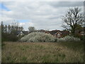
Blackthorn in flower, Upper Saxondale
Image: © Jonathan Thacker
Taken: 16 Apr 2021
0.10 miles
7
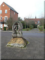
Millennium Walk (5)
Sculpture at the northern end of the walk, it mirrors the obelisk at the southern end and represents the year 1000.
Image: © Alan Murray-Rust
Taken: 8 Dec 2009
0.10 miles
8
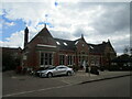
Former administration building, Nottinghamshire County Asylum
Now a restaurant.
Image: © Jonathan Thacker
Taken: 16 Apr 2021
0.10 miles
9
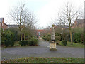
Millennium Walk (1)
This was the central walkway through the old hospital and has been developed as a formal walk to commemorate the Millennium. The obelisk is inscribed M for the year 1000, and slabs in the paving mark the passage of centuries before reaching the small pillar on the podium, inscribed MM.
Image: © Alan Murray-Rust
Taken: 8 Dec 2009
0.11 miles
10
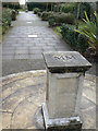
Millennium Walk (4)
MM for 2000 is inscribed in the top of a short pillar on a circular podium at the midpoint of the walk. (see http://www.geograph.org.uk/photo/1614856 )
Image: © Alan Murray-Rust
Taken: 8 Dec 2009
0.11 miles