IMAGES TAKEN NEAR TO
Island Lane, NOTTINGHAM, NG12 2LW
Introduction
This page details the photographs taken nearby to Island Lane, NG12 2LW by members of the Geograph project.
The Geograph project started in 2005 with the aim of publishing, organising and preserving representative images for every square kilometre of Great Britain, Ireland and the Isle of Man.

There are currently over 7.5m images from over14,400 individuals and you can help contribute to the project by visiting https://www.geograph.org.uk
Image Map
Images are licensed for reuse under creativecommons.org/licenses/by-sa/2.0
Notes
- Clicking on the map will re-center to the selected point.
- The higher the marker number, the further away the image location is from the centre of the postcode.
Image Listing (35 Images Found)
Images are licensed for reuse under creativecommons.org/licenses/by-sa/2.0
Image
Details
Distance
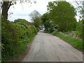
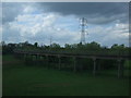
1
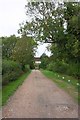
View along track under bridge of dismantled railway
Image: © Roger Templeman
Taken: 10 Sep 2018
0.07 miles
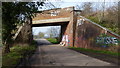
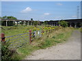
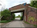
2
Two Railway Bridges
As far as I'm aware the short lane from this photo is taken is unnamed. I think the line carried by the first bridge is disused.
Image: © Oxymoron
Taken: 23 Jul 2008
0.08 miles
3
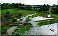
Level rising
Polser Brook risen beyond its banks near Ratcliffe.
Image: © Donnylad
Taken: 23 Jun 2007
0.13 miles
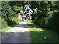
4
Holme Lane
Looking east from the former railway bridge to Radcliffe.
Image: © Alan Murray-Rust
Taken: 30 Apr 2020
0.14 miles
5
Junction of Two Railway Bridges
This photo is taken from under the disused bridge shown in http://www.geograph.org.uk/photo/893805.
Image: © Oxymoron
Taken: 23 Jul 2008
0.16 miles
6
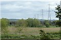
Former railway viaduct
This formed the western curve of the triangular junction of the Cotgrave Colliery branch with the Nottingham to Grantham line.
Image: © Alan Murray-Rust
Taken: 30 Apr 2020
0.16 miles
7
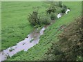
Polser Brook
The meandering Polser Brook that runs from Holme Pierrepoint to the River Trent, near Radcliffe on Trent. The recent rain has turned the water red/brown as it has washed soil from the nearby land.
Image: © Donnylad
Taken: 28 May 2007
0.16 miles
8
Rail spur from Radcliffe
As viewed from the 09.06 from Skegness to Nottingham train.
Image: © Richard Hoare
Taken: 7 May 2010
0.16 miles
9
Railway bridge over Holme Lane
This was the branch line to Cotgrave Colliery, closed in 1993. To the left the line has been converted to a multi-user path to Cotgrave Country Park.
Image: © Alan Murray-Rust
Taken: 30 Apr 2020
0.18 miles