IMAGES TAKEN NEAR TO
Radcliffe Road, NOTTINGHAM, NG12 2LT
Introduction
This page details the photographs taken nearby to Radcliffe Road, NG12 2LT by members of the Geograph project.
The Geograph project started in 2005 with the aim of publishing, organising and preserving representative images for every square kilometre of Great Britain, Ireland and the Isle of Man.

There are currently over 7.5m images from over14,400 individuals and you can help contribute to the project by visiting https://www.geograph.org.uk
Image Map
Images are licensed for reuse under creativecommons.org/licenses/by-sa/2.0
Notes
- Clicking on the map will re-center to the selected point.
- The higher the marker number, the further away the image location is from the centre of the postcode.
Image Listing (12 Images Found)
Images are licensed for reuse under creativecommons.org/licenses/by-sa/2.0
Image
Details
Distance
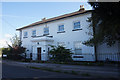
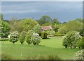
2
Holme House, Holme Pierrepont
At the junction of the A52 and Stragglethorpe Road
Image: © Eirian Evans
Taken: 30 Jul 2022
0.02 miles
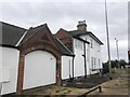
3
Holme House
Located at the junction of the A52 and Stragglethorpe Road, a very noisy location.
Image: © Oxymoron
Taken: 23 Jul 2008
0.03 miles
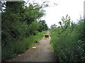
4
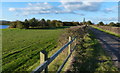
A patch of sunlight
Looking west from the bridleway.
Image: © Alan Murray-Rust
Taken: 30 Apr 2020
0.06 miles
5
'Sandy Lane' or 'Sanday's Lane'? Proposed Byway
I'm confused about the name of this lane running from the A52 (behind camera) to Holme Pierrepont. The OS map says 'Sandy Lane', but other evidence - including a Planning Inspectorate decision to make it a byway open to all traffic indicates 'Sanday's Lane' (Planning Inspectorate Order ref. FPS/L3055/7/36M)
Image: © Tim Heaton
Taken: 29 Jun 2008
0.13 miles
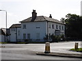
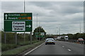
6
A52, Radcliffe Road near Holme Pierrepont
Image: © David Dixon
Taken: 8 Aug 2014
0.13 miles
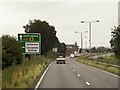
7
A52 sign for Cropwell Bishop junction
Cropwell Bishop is famous for its Stilton Cheese.
Image: © J.Hannan-Briggs
Taken: 14 May 2013
0.15 miles
8
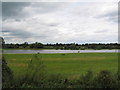
Fishing Lake
Viewed from the A52 looking towards Holme Pierrepont. One of several lakes in this large area of former gravel pits.
Image: © Tim Heaton
Taken: 29 Jun 2008
0.21 miles
9
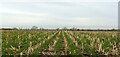
Stubble and new crop
Corn stubble with new cereal planting.
Modern computer guidance of tractors allows the new crop to be sown precisely between the rows of the previous year's crop.
Image: © Alan Murray-Rust
Taken: 1 Jan 2022
0.21 miles