IMAGES TAKEN NEAR TO
Holme Lane, NOTTINGHAM, NG12 2LB
Introduction
This page details the photographs taken nearby to Holme Lane, NG12 2LB by members of the Geograph project.
The Geograph project started in 2005 with the aim of publishing, organising and preserving representative images for every square kilometre of Great Britain, Ireland and the Isle of Man.

There are currently over 7.5m images from over14,400 individuals and you can help contribute to the project by visiting https://www.geograph.org.uk
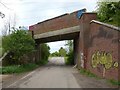
Image Map
Images are licensed for reuse under creativecommons.org/licenses/by-sa/2.0
Notes
- Clicking on the map will re-center to the selected point.
- The higher the marker number, the further away the image location is from the centre of the postcode.
Image Listing (31 Images Found)
Images are licensed for reuse under creativecommons.org/licenses/by-sa/2.0
Image
Details
Distance
1
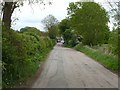
Holme Lane
Looking east from the former railway bridge to Radcliffe.
Image: © Alan Murray-Rust
Taken: 30 Apr 2020
0.11 miles
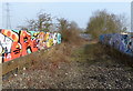
2
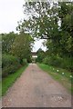
View along track under bridge of dismantled railway
Image: © Roger Templeman
Taken: 10 Sep 2018
0.13 miles
3
Two Railway Bridges
As far as I'm aware the short lane from this photo is taken is unnamed. I think the line carried by the first bridge is disused.
Image: © Oxymoron
Taken: 23 Jul 2008
0.14 miles
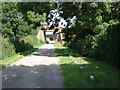
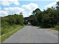
5
Railway bridge over Holme Lane
This was the branch line to Cotgrave Colliery, closed in 1993. To the left the line has been converted to a multi-user path to Cotgrave Country Park.
Image: © Alan Murray-Rust
Taken: 30 Apr 2020
0.16 miles
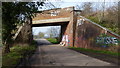
6
Graffiti covered disused railway bridge
Crossing Holme Lane near Holme Pierrepont.
Image: © Mat Fascione
Taken: 12 Mar 2016
0.16 miles
7
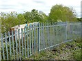
The end of the path
The fenced off section of the former Cotgrave Colliery branch at the end of the multi-user path from the country park.
Image: © Alan Murray-Rust
Taken: 30 Apr 2020
0.16 miles
8
Holme Lane bridge
Railway bridge on the Trent Valley Way
Image: © Richard Croft
Taken: 15 Jul 2011
0.16 miles
9
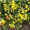
Ham and Eggs, Eggs and Bacon, etc
Aka Bird's-foot Trefoil (Lotus corniculatus). The name 'bird's foot' refers to the appearance of the seed pods on their stalk, although as can be seen here the buds form a similar pattern (mid-upper right) before opening. The common name derives from the mix of red and yellow colouring. See http://www.geograph.org.uk/photo/6459454 for a fuller view of the plant.
Image: © Alan Murray-Rust
Taken: 30 Apr 2020
0.16 miles
10
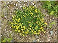
Ham and Eggs, Eggs and Bacon, etc
Aka Bird's-foot Trefoil (Lotus corniculatus), growing on the old railway embankment. The name 'bird's foot' refers to the appearance of the seed pods on their stalk, although as can be seen here the buds form a similar pattern. The common name derives from the mix of red and yellow colouring. See http://www.geograph.org.uk/photo/6459452 for a close-up of the flowers.
Image: © Alan Murray-Rust
Taken: 30 Apr 2020
0.16 miles