IMAGES TAKEN NEAR TO
The Green, NOTTINGHAM, NG12 2LA
Introduction
This page details the photographs taken nearby to The Green, NG12 2LA by members of the Geograph project.
The Geograph project started in 2005 with the aim of publishing, organising and preserving representative images for every square kilometre of Great Britain, Ireland and the Isle of Man.

There are currently over 7.5m images from over14,400 individuals and you can help contribute to the project by visiting https://www.geograph.org.uk
Image Map
Images are licensed for reuse under creativecommons.org/licenses/by-sa/2.0
Notes
- Clicking on the map will re-center to the selected point.
- The higher the marker number, the further away the image location is from the centre of the postcode.
Image Listing (38 Images Found)
Images are licensed for reuse under creativecommons.org/licenses/by-sa/2.0
Image
Details
Distance

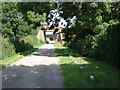
4
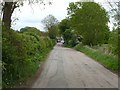
Holme Lane
Looking east from the former railway bridge to Radcliffe.
Image: © Alan Murray-Rust
Taken: 30 Apr 2020
0.17 miles
5
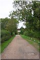
View along track under bridge of dismantled railway
Image: © Roger Templeman
Taken: 10 Sep 2018
0.17 miles
6
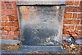
Benchmark on Nottingham Road wall pier
Ordnance Survey cut mark benchmark described on the Bench Mark Database at https://www.bench-marks.org.uk/bm99464
Image: © Roger Templeman
Taken: 10 Sep 2018
0.18 miles
7
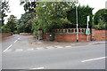
Junction of Nottingham Road and Yew Tree Close
There is an OS benchmark Image on the wall pier right of the bus stop sign
Image: © Roger Templeman
Taken: 10 Sep 2018
0.18 miles
8
Two Railway Bridges
As far as I'm aware the short lane from this photo is taken is unnamed. I think the line carried by the first bridge is disused.
Image: © Oxymoron
Taken: 23 Jul 2008
0.18 miles
9

Recreation ground
Equipped with a variety of modern constructions.
Image: © Alan Murray-Rust
Taken: 23 Oct 2009
0.20 miles
10
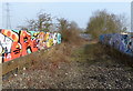
Graffiti covered disused railway bridge
Crossing Holme Lane near Holme Pierrepont.
Image: © Mat Fascione
Taken: 12 Mar 2016
0.21 miles