IMAGES TAKEN NEAR TO
Stragglethorpe, Radcliffe-on-Trent, NOTTINGHAM, NG12 2JW
Introduction
This page details the photographs taken nearby to NG12 2JW by members of the Geograph project.
The Geograph project started in 2005 with the aim of publishing, organising and preserving representative images for every square kilometre of Great Britain, Ireland and the Isle of Man.

There are currently over 7.5m images from over14,400 individuals and you can help contribute to the project by visiting https://www.geograph.org.uk
Image Map
Images are licensed for reuse under creativecommons.org/licenses/by-sa/2.0
Notes
- Clicking on the map will re-center to the selected point.
- The higher the marker number, the further away the image location is from the centre of the postcode.
Image Listing (10 Images Found)
Images are licensed for reuse under creativecommons.org/licenses/by-sa/2.0
Image
Details
Distance
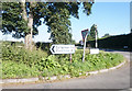
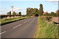
1
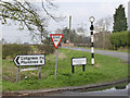
Fingerpost at Stragglethorpe, Hollygate Lane
Traditional Notts CC cast iron post with ring finial.
Image: © Alan Murray-Rust
Taken: 28 Mar 2014
0.09 miles
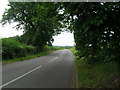
5
Hollygate Farm near Cotgrave
Viewed from the Grantham Canal.
Image: © Mat Fascione
Taken: 12 Nov 2017
0.11 miles
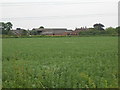
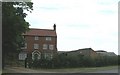
7
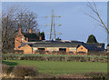
Hollygate Farm
Seen from near Mann's Bridge on Stragglethorpe Lane. This is one of just a handful of farms which make up the very scattered community of Stragglethorpe, which well deserves its name.
Image: © Alan Murray-Rust
Taken: 6 Dec 2009
0.12 miles