IMAGES TAKEN NEAR TO
Radcliffe Road, NOTTINGHAM, NG12 2JT
Introduction
This page details the photographs taken nearby to Radcliffe Road, NG12 2JT by members of the Geograph project.
The Geograph project started in 2005 with the aim of publishing, organising and preserving representative images for every square kilometre of Great Britain, Ireland and the Isle of Man.

There are currently over 7.5m images from over14,400 individuals and you can help contribute to the project by visiting https://www.geograph.org.uk
Image Map
Images are licensed for reuse under creativecommons.org/licenses/by-sa/2.0
Notes
- Clicking on the map will re-center to the selected point.
- The higher the marker number, the further away the image location is from the centre of the postcode.
Image Listing (14 Images Found)
Images are licensed for reuse under creativecommons.org/licenses/by-sa/2.0
Image
Details
Distance

2

The Grove
Attractive house on the outskirts of Cropwell Butler. Dating from 1837, it probably counts as William IV rather than Victorian. Listed Grade II.
Image: © Alan Murray-Rust
Taken: 6 Dec 2009
0.06 miles
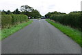
3
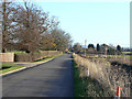
Radcliffe Road
Looking towards the village of Cropwell Butler from near the A46.
Image: © Alan Murray-Rust
Taken: 6 Dec 2009
0.14 miles
4
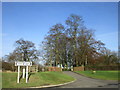
Entrance to the Grove, Cropwell Butler
The footpath sign points to a new footpath which follows the route of the old A46 (Fosse Way).
Image: © Jonathan Thacker
Taken: 3 Feb 2017
0.14 miles

6
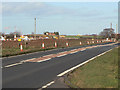
A46 near Cropwell Butler
Looking north at the works from Radcliffe Road junction. At this point the new road sweeps round to the west to form a brand new junction with the A52 to the west of the existing Saxondale Island.
Image: © Alan Murray-Rust
Taken: 6 Dec 2009
0.17 miles

9
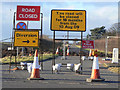
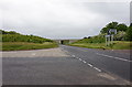
Radcliffe Road
The signs leave one in no doubt about the status of the road - it's closed! The reason is that it is cut by construction of the new dual carriageway A46.
Looking northwest at the A46 crossroads.
Image: © Alan Murray-Rust
Taken: 6 Dec 2009
0.18 miles
10
Cross Roads
This square is mainly farmland but the A 46 slices across the middle.
Image: © Daniel Robinson
Taken: 30 Aug 2006
0.18 miles