IMAGES TAKEN NEAR TO
Parr Court, NOTTINGHAM, NG12 2AU
Introduction
This page details the photographs taken nearby to Parr Court, NG12 2AU by members of the Geograph project.
The Geograph project started in 2005 with the aim of publishing, organising and preserving representative images for every square kilometre of Great Britain, Ireland and the Isle of Man.

There are currently over 7.5m images from over14,400 individuals and you can help contribute to the project by visiting https://www.geograph.org.uk
Image Map
Images are licensed for reuse under creativecommons.org/licenses/by-sa/2.0
Notes
- Clicking on the map will re-center to the selected point.
- The higher the marker number, the further away the image location is from the centre of the postcode.
Image Listing (87 Images Found)
Images are licensed for reuse under creativecommons.org/licenses/by-sa/2.0
Image
Details
Distance
1
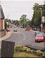
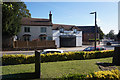
Radcliffe-on-Trent, Notts.
Main Road in the direction of Bingham Road, seen from the corner of the elevated graveyard of St Mary's Church. The driveway entrance into "The Grange" function venue is behind the first lamp-post on the right.
Image: © David Hallam-Jones
Taken: 20 Jul 2013
0.02 miles
2
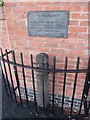
The Whipping Post, Radcliffe on Trent
The plaque says that the post was restored by the local Council in 1996 following 'vandalism'. Perhaps it still has a use?
Image: © Tim Heaton
Taken: 24 Aug 2008
0.02 miles
3
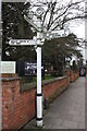
Brick wall on south side of Main Street outside Grange Hall
The fingerpost has Milestone Society National ID: NT_SK6439
Image: © Roger Templeman
Taken: 18 Jan 2019
0.02 miles
4
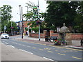
Radcliffe-on-Trent, Notts.
Main Road approaching its junction with Vicarage Lane. This defunct water trough (and drinking fountain on the reverse side) was erected to commemorate the coronation of Edward VII in Westminster Abbey on 9 August 1902. The pedestrian gate beyond it gives access to "The Grange", a function venue set in beautifully tended public gardens.
Image: © David Hallam-Jones
Taken: 20 Jul 2013
0.02 miles
5

Walnut Court
A small private courtyard of cottages off Walnut Grove.
Image: © Kate Jewell
Taken: 5 Sep 2013
0.02 miles
6

Drinking trough and fountain
On Main Road in the centre of Radcliffe on Trent.
Horses and cattle could drink from the roadside, humans and dogs on the pavement side.
Image: © Alan Murray-Rust
Taken: 23 Oct 2009
0.03 miles
8
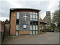
St. Mary's Hall, Radcliffe on Trent
The hall to St. Mary's church which can be seen behind.
Image: © Jonathan Thacker
Taken: 16 Apr 2021
0.03 miles
9

Fingerpost at Radcliffe
This is a modern version of the traditional cast iron type. The detailed styling and lettering is distinctly different from the traditional ones.
Image: © Alan Murray-Rust
Taken: 23 Oct 2009
0.03 miles
10
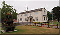
Radcliffe-on-Trent, Notts.
The Grange, seen from inside the boundary wall separating it the property from Main Street, is a function venue set in well maintained gardens. Amongst other groups, the Parish Council use it as a venue for its meetings. Behind it there is children's play area. To the left of it (though not visible) is the more recently built Grange Hall, a second 'function venue' capable of seating audiences of several hunded people for amateur dramatic productions, conferences and wedding receptions. The Totem pole in the picture was installed on 3rd May 2013 to reflect a longstanding connection between Radcliffe and a group of Canadian families who spent time in the town. After WWII a housing estate for Canadian airmen who had served at nearby RAF Langar was built in Radcliffe. In the early 60s a Canadian teenager carved three totem poles as a thank-you gesture but these it seems had become lost and/or perished. This replacement was had carved by a local resident who was a lad when the Canadians were temporary residents in the town.
Image: © David Hallam-Jones
Taken: 20 Jul 2013
0.04 miles