IMAGES TAKEN NEAR TO
Ridge Lane, NOTTINGHAM, NG12 1BD
Introduction
This page details the photographs taken nearby to Ridge Lane, NG12 1BD by members of the Geograph project.
The Geograph project started in 2005 with the aim of publishing, organising and preserving representative images for every square kilometre of Great Britain, Ireland and the Isle of Man.

There are currently over 7.5m images from over14,400 individuals and you can help contribute to the project by visiting https://www.geograph.org.uk
Image Map
Images are licensed for reuse under creativecommons.org/licenses/by-sa/2.0
Notes
- Clicking on the map will re-center to the selected point.
- The higher the marker number, the further away the image location is from the centre of the postcode.
Image Listing (79 Images Found)
Images are licensed for reuse under creativecommons.org/licenses/by-sa/2.0
Image
Details
Distance
1
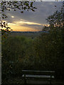
Evening light at Radcliffe
One of the points where there is half a glimpse through the trees that cover the cliffs alongside the River Trent.
Image: © Alan Murray-Rust
Taken: 23 Oct 2009
0.09 miles
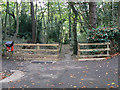
2
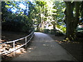
Footpath to Valley Road, Radcliffe on Trent
From The Avenue linear park near Slack Hollow.
Image: © Richard Vince
Taken: 26 Aug 2013
0.09 miles
3
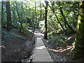
Steps to the Trent near Slack Hollow
A steep footpath to the bottom of the cliffs from The Avenue, a linear park that runs along the top. The concrete steps in the foreground appear to have been installed recently.
Image: © Richard Vince
Taken: 26 Aug 2013
0.09 miles
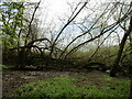
4
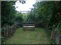
Seat without a view, The Cliffs.
A great many seats have been thoughtfully provided along the narrow strip of park sited on top of the cliffs overlooking the Trent Valley. None of them have any view. Judicious pruning at some locations might be beneficial.
Image: © Tim Heaton
Taken: 24 Aug 2008
0.10 miles
5
Footpath at the bottom of The Cliffs
Image: © Jonathan Thacker
Taken: 16 Apr 2021
0.10 miles
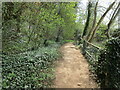
7
Down to the river
There are just a couple of places where the cliffs ease off enough to allow a pathway down to the river. This is Slack Hollow at the end of Valley Road.
Image: © Alan Murray-Rust
Taken: 23 Oct 2009
0.11 miles
8

Stoke weir, River Trent
Boom to prevent craft being swept down the weir
Image: © Peter Barr
Taken: 4 Mar 2009
0.12 miles
9
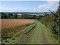
Track down Gibbet Hill
The Trent Valley Way runs left to right along the line of trees at the bottom of the slope.
Image: © Tim Heaton
Taken: 24 Aug 2008
0.12 miles
10
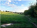
The Trent Valley Way at Gibbet Hill
Looking towards the northern fringes of Radcliffe on Trent.
Image: © Jonathan Clitheroe
Taken: 5 Oct 2024
0.12 miles