IMAGES TAKEN NEAR TO
Oaktree Avenue, NOTTINGHAM, NG12 1AD
Introduction
This page details the photographs taken nearby to Oaktree Avenue, NG12 1AD by members of the Geograph project.
The Geograph project started in 2005 with the aim of publishing, organising and preserving representative images for every square kilometre of Great Britain, Ireland and the Isle of Man.

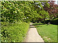
There are currently over 7.5m images from over14,400 individuals and you can help contribute to the project by visiting https://www.geograph.org.uk
Image Map
Images are licensed for reuse under creativecommons.org/licenses/by-sa/2.0
Notes
- Clicking on the map will re-center to the selected point.
- The higher the marker number, the further away the image location is from the centre of the postcode.
Image Listing (73 Images Found)
Images are licensed for reuse under creativecommons.org/licenses/by-sa/2.0
Image
Details
Distance
1
Trent Valley way on the edge of Radcliffe on Trent
Image: © Andy Jamieson
Taken: 8 May 2008
0.10 miles
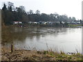
2
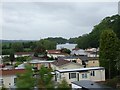
Riverside retreat
Chalet park on the East bank of the River Trent. Stoke Lock can be seen in the distance above the rooves of the chalets.
Image: © Donnylad
Taken: 28 May 2007
0.10 miles
3
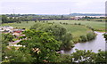
Radcliffe-on-Trent, Notts.
The River Trent with the Netherfield railway viaduct, crossing the Trent and the Trent flood plain, in the distance. On the left margin of the picture is an estate of mobile homes known as Radcliffe Park (off Wharf Lane). This picture was taken from a cliff-top path - designated The Avenue at this point - that extends from Radcliffe towards Gibbet Hill (to the left of this view). This path hugs the edge of the top of a 15-20 foot wide strip of open land situated on the top of some impressive shale cliffs overlooking the River Trent. This cliff-top walk and Rockley Memorial Park (of the flower garden type), a mile or so away, was gifted to the town's inhabitants by Mr Lisle Rockley in memory of his son, who was killed at Ypres during WWI. The Trent acts as the administrative boundary between Gedling, NG14 and Radcliffe, NG12.
Image: © David Hallam-Jones
Taken: 21 Jul 2013
0.10 miles
4
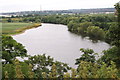
Radcliffe-on-Trent, Notts.
The River Trent with Netherfield Lagoons Nature Reserve and the suburbs of Netherfield, Colwick and Carlton in the distance. This picture was taken from the cliff-top path - designated The Avenue at this point - that extends from Radcliffe towards Gibbet Hill (to the left of this view). This path hugs the edge of the top of a 15-20 foot wide strip of open land situated on the top of some impressive shale cliffs overlooking the River Trent. This cliff-top walk and Rockley Memorial Park (of the flower garden type), a mile or so away, was gifted to the town's inhabitants by Mr Lisle Rockley in memory of his son, who was killed at Ypres during WWI. The river acts as an administrative boundary between Gedling NG14 and NG12.
Image: © David Hallam-Jones
Taken: 21 Jul 2013
0.11 miles
5
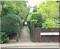
Radcliffe-on-Trent, Notts.
An access point onto the Trent Valley Path from Grandfield Crescent. By turning right at the other end of this alleyway pedestrians can reach Rockley Memorial Park (3-4 minutes walk) and a branch footpath downhill to the side of the River Trent (20-25 minutes walk), whilst to the left walkers can reach Radcliffe railway station via Fernwood Drive (a 10 minute walk). From the Trent Valley Path there are views of the River Trent and the distant Netherfield Lagoons Nature Reserve.
Image: © David Hallam-Jones
Taken: 21 Jul 2013
0.11 miles
6
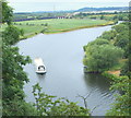
Radcliffe-on-Trent, Notts.
A passenger cruiser on the River Trent, with the Netherfield railway viaduct, crossing the Trent and the Trent flood plain, in the distance. This picture was taken from a cliff-top path - designated The Avenue at this point - that extends from Radcliffe towards Gibbet Hill (to the left of this view). This path hugs the edge of the top of a 15-20 foot wide strip of open land situated on the top of some impressive shale cliffs overlooking the river. This cliff-top walk and Rockley Memorial Park (of the flower garden type), a mile or so away, was gifted to the town's inhabitants by Mr Lisle Rockley in memory of his son, who was killed at Ypres during WWI. The Trent acts as the administrative boundary between Gedling, NG14 and Radcliffe, NG12.
Image: © David Hallam-Jones
Taken: 21 Jul 2013
0.11 miles
7
Radcliffe Residential Park next to the River Trent
Image: © Mat Fascione
Taken: 12 Mar 2016
0.12 miles
8
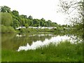
Chalets at Radcliffe on Trent
Recreating this 'First' for the square http://www.geograph.org.uk/photo/43285
Image: © Alan Murray-Rust
Taken: 28 May 2021
0.12 miles
9
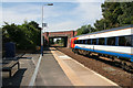
Shelford Road Bridge
Looking towards Nottingham from the station at Radcliffe on Trent. Netherfield on the north side of the River Trent is the next station.
Image: © Kate Jewell
Taken: 5 Sep 2013
0.12 miles
10
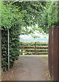
Radcliffe-on-Trent, Notts.
An access point onto the Trent Valley Path from Grandfield Crescent, via an alleyway. By turning right, pedestrians can reach Rockley Memorial Park (3-4 minutes walk) and a branch footpath downhill to the side of the River Trent (20-25 minutes walk), whilst to the left walkers can Radcliffe railway station via Fernwood Drive (a 10 minute walk). Beyond the fence are views of the River Trent and the distant Netherfield Lagoons Nature Reserve.
Image: © David Hallam-Jones
Taken: 21 Jul 2013
0.12 miles