IMAGES TAKEN NEAR TO
Brightmoor Street, NOTTINGHAM, NG1 1FD
Introduction
This page details the photographs taken nearby to Brightmoor Street, NG1 1FD by members of the Geograph project.
The Geograph project started in 2005 with the aim of publishing, organising and preserving representative images for every square kilometre of Great Britain, Ireland and the Isle of Man.

There are currently over 7.5m images from over14,400 individuals and you can help contribute to the project by visiting https://www.geograph.org.uk
Image Map
Images are licensed for reuse under creativecommons.org/licenses/by-sa/2.0
Notes
- Clicking on the map will re-center to the selected point.
- The higher the marker number, the further away the image location is from the centre of the postcode.
Image Listing (1314 Images Found)
Images are licensed for reuse under creativecommons.org/licenses/by-sa/2.0
Image
Details
Distance
1
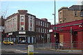
Hockley and Cranbrook Street
Hockley in the foreground, Cranbrook Street receding to the right. This part of town just east of the City Centre has loss its trading importance over the years, now being confined to a number of specialist shops and a few eating establishments. The former prosperity of this area as a retail area can be envisaged when it is pointed out that the building opposite (Emmanuel House) was formerly Montague Burton in their distinctive architectural style. The ground floor is now a second hand shop supporting the homeless; the upper floors, styled Burton Chambers (the logo is just visible above the door to the right). Similarly the red building to the right used to be a branch of Woolworth. It is now an out of use nightclub. Some of the decorative surrounds to the show windows, in a clearly recognisable Woolworth style still exist.
Image: © Alan Murray-Rust
Taken: 27 Jan 2008
0.01 miles
2
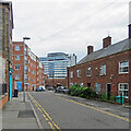
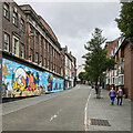
Contrasting styles on Brightmoor Street
Inner-city housing of different periods in the Hockley district, not far from Nottingham city centre.
Image: © John Sutton
Taken: 28 Jul 2022
0.01 miles
3
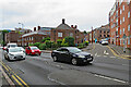
On Cranbrook Street
Inner-city housing of different periods in the Hockley district, not far from Nottingham city centre.
Image: © John Sutton
Taken: 28 Jul 2022
0.02 miles
4
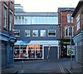
Goose Gate, Hockley, Nottingham 1
A section of Goose Gate seen from Brightmoor Street. The left-hand corner shop dates back to the early 1900s although it has stood empty for several years. It was once a haberdasher's shop and also saw service as a greengrocer's shop in the 70s and 80s. Later in 2017 it is due to open as "The Urban Kitchen", i.e. another Hockley 'eatery'.
Image: © David Hallam-Jones
Taken: 2 Jan 2017
0.02 miles
5
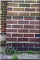
Benchmark on #40 Cranbrook Street
Ordnance Survey cut mark benchmark described on the Bench Mark Database at http://www.bench-marks.org.uk/bm34278
Image: © Roger Templeman
Taken: 30 Mar 2013
0.02 miles
6
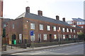
Houses on Cranbrook Street
There is an OS benchmark Image on the road face of the corner of the near house
Image: © Roger Templeman
Taken: 30 Mar 2013
0.02 miles
7
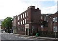
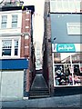
Hockley: former Montague Burton shop
The Cranbrook Street side of a shop built in the 1930s for the fifty-shilling tailor. Alan Murray-Rust's Image] shows the shop front at the Goose Gate end of the building.
Image: © John Sutton
Taken: 10 May 2012
0.03 miles
8
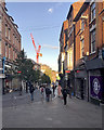
Down Goose Gate
The edge of The Lace Market early on a fine September evening. The picture was taken at the corner of Heathcote Street
Image: © John Sutton
Taken: 17 Sep 2019
0.03 miles
9
Wing Walk, Hockley, Nottingham 1
Wing Walk, leading to Woolpack Lane, seen from Goose Gate.
Image: © David Hallam-Jones
Taken: 2 Jan 2017
0.03 miles
10
Up Goose Gate on a grey morning
On the edge of The Lace Market, looking up the hill towards the junction of Stoney Street, Broad Street and Heathcote Street. A cloudy early-September morning became brighter, but there were storms later.
Image: © John Sutton
Taken: 7 Sep 2022
0.03 miles