IMAGES TAKEN NEAR TO
Cranbrook Street, NOTTINGHAM, NG1 1ES
Introduction
This page details the photographs taken nearby to Cranbrook Street, NG1 1ES by members of the Geograph project.
The Geograph project started in 2005 with the aim of publishing, organising and preserving representative images for every square kilometre of Great Britain, Ireland and the Isle of Man.

There are currently over 7.5m images from over14,400 individuals and you can help contribute to the project by visiting https://www.geograph.org.uk
Image Map
Images are licensed for reuse under creativecommons.org/licenses/by-sa/2.0
Notes
- Clicking on the map will re-center to the selected point.
- The higher the marker number, the further away the image location is from the centre of the postcode.
Image Listing (1032 Images Found)
Images are licensed for reuse under creativecommons.org/licenses/by-sa/2.0
Image
Details
Distance
1
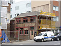
Secret writing uncovered
Demolition of part of the buildings at the former Byron Works has revealed this painted sign relating to the original owners of the works, part of the Nottingham lace-making heritage. Latterly the works were occupied by a cardboard box manufacturer.
Image: © Alan Murray-Rust
Taken: 23 Aug 2012
0.01 miles
2
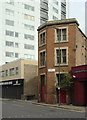
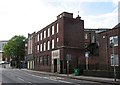
Contrast in styles
The brick building is a former industrial premises, now no longer in demand. Even the tower block behind has changed use, having been built for offices before being converted to flats a few years ago. Although not legible in detail, the road name on the building makes reference to the renaming of a number of roads in this area as a result of a road improvement scheme. This one reads Cranbrook Street formerly Coalpit Lane.
Image: © Alan Murray-Rust
Taken: 27 Apr 2008
0.02 miles
3
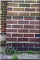
Benchmark on #40 Cranbrook Street
Ordnance Survey cut mark benchmark described on the Bench Mark Database at http://www.bench-marks.org.uk/bm34278
Image: © Roger Templeman
Taken: 30 Mar 2013
0.03 miles
4
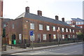
Houses on Cranbrook Street
There is an OS benchmark Image on the road face of the corner of the near house
Image: © Roger Templeman
Taken: 30 Mar 2013
0.03 miles
5
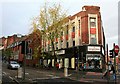
Hockley: former Montague Burton shop
The Cranbrook Street side of a shop built in the 1930s for the fifty-shilling tailor. Alan Murray-Rust's Image] shows the shop front at the Goose Gate end of the building.
Image: © John Sutton
Taken: 10 May 2012
0.03 miles
6
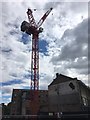
Crane on the site of a night club
Image: © David Lally
Taken: 5 Aug 2017
0.03 miles
7
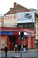
Old and modern advertising
At the junction of Hockley and Cranbrook Street, Nottingham.
The Berlins club on the corner has been closed for some time.
Image: © David Lally
Taken: 14 Nov 2009
0.03 miles
8
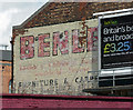
Ghost sign, Hockley, Nottingham
It reads:
"BENLE[Y?]
Ladies and Childrens Fashions
Household Linens
Furniture & Carpets"
Image: © Stephen Richards
Taken: 18 Jun 2012
0.04 miles
9
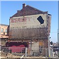
Ghost sign
A single storey building has been demolished and a modern hoarding removed since Image, revealing more of the old sign.
Image: © David Lally
Taken: 6 Apr 2015
0.04 miles
10
Emmanuel House Day Centre
At least that's what the sign says. I have no knowledge of the history of this building, but it looks to have been built in the 1930s.
Image: © David Lally
Taken: 14 Nov 2009
0.04 miles