IMAGES TAKEN NEAR TO
Huntingdon Street, NOTTINGHAM, NG1 1AT
Introduction
This page details the photographs taken nearby to Huntingdon Street, NG1 1AT by members of the Geograph project.
The Geograph project started in 2005 with the aim of publishing, organising and preserving representative images for every square kilometre of Great Britain, Ireland and the Isle of Man.

There are currently over 7.5m images from over14,400 individuals and you can help contribute to the project by visiting https://www.geograph.org.uk
Image Map
Images are licensed for reuse under creativecommons.org/licenses/by-sa/2.0
Notes
- Clicking on the map will re-center to the selected point.
- The higher the marker number, the further away the image location is from the centre of the postcode.
Image Listing (743 Images Found)
Images are licensed for reuse under creativecommons.org/licenses/by-sa/2.0
Image
Details
Distance
1
Post Office history
The old Post Office organisation dominates this view eastwards from the big wheel in the Old Market Square. The building bottom right is a former telephone exchange, now converted to apartments, including additional storeys. Beyond, the large business with the rounded ends is the former central sorting office. This too has had additional floors built on, and has been converted to apartments. The tower block behind still functions as a telephone exchange.
Image: © Alan Murray-Rust
Taken: 19 Apr 2009
0.01 miles
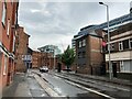
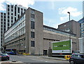
2
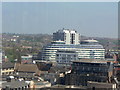
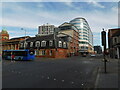
Concrete canyon, Huntingdon Street
Looking north from very near the bottom of Huntingdon Street. The scene is dominated by Marco Island (right) and the Litmus building (centre).
Image: © Richard Vince
Taken: 28 Jun 2012
0.03 miles
3
Nottingham Delivery Office
The royal Mail downsized into this building from the adjacent former sorting office (out of view left) which has been converted into apartments.
Image: © Alan Murray-Rust
Taken: 17 Jun 2008
0.03 miles
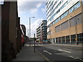
4
Beck Street (north)
The northern half of Beck Street, seen from Huntingdon Street.
Image: © Richard Vince
Taken: 28 Jun 2012
0.04 miles
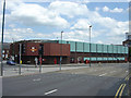
6
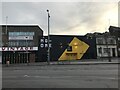
NG-One nightclub, Lower Parliament Street
Image: © Bryn Holmes
Taken: 4 Mar 2020
0.05 miles
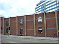
7
1 Brook Street, Nottingham
Big 1960s or 1970s office block and depot as seen from Bath Street. John Beniston tells me that it was built in the late 1960s for the GPO as a "mechanised Parcel Concentration (sorting) Office, and offices for Nottingham's head postmaster". It closed in the early 1990s.
At the time partly occupied by Hertz car rental. An application in 2006 to demolish and replace with a residential tower was clearly either rejected or stymied by the recession.
The telephone exchange is behind (Image]).
Image: © Stephen Richards
Taken: 18 Jun 2012
0.05 miles
8
Filling station
The title is not wrong - it is the back wall of a filling station on the neighbouring street. The round-headed openings reflect the style of many of the small lace factories formerly found in this part of the city.
Image: © Alan Murray-Rust
Taken: 17 Jun 2008
0.06 miles
9
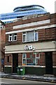
Small Art-Deco Office
On Cranbrook's Street, Hockley, Nottingham. With recent apartment block peeping over.
Image: © David Lally
Taken: 14 Nov 2009
0.06 miles
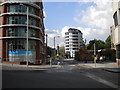
10
King Edward Street/A60, Nottingham city centre
Image: © Bryn Holmes
Taken: 16 Mar 2020
0.06 miles