IMAGES TAKEN NEAR TO
Highwray Grove, NOTTINGHAM, NG11 9JJ
Introduction
This page details the photographs taken nearby to Highwray Grove, NG11 9JJ by members of the Geograph project.
The Geograph project started in 2005 with the aim of publishing, organising and preserving representative images for every square kilometre of Great Britain, Ireland and the Isle of Man.

There are currently over 7.5m images from over14,400 individuals and you can help contribute to the project by visiting https://www.geograph.org.uk
Image Map
Images are licensed for reuse under creativecommons.org/licenses/by-sa/2.0
Notes
- Clicking on the map will re-center to the selected point.
- The higher the marker number, the further away the image location is from the centre of the postcode.
Image Listing (28 Images Found)
Images are licensed for reuse under creativecommons.org/licenses/by-sa/2.0
Image
Details
Distance
1
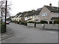
Clifton - Highwray Grove
The circular street name boards are an unusual, distinctive feature of this otherwise rather utilitarian and sizable council house estate.
Image: © Peter Whatley
Taken: 22 Mar 2009
0.07 miles
2
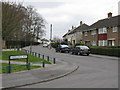
Clifton - Whitegate Vale at Middlefell Way
Image: © Peter Whatley
Taken: 22 Mar 2009
0.08 miles
3
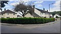
#115 Gardendale Avenue and houses on Cliffmere Walk
Ordnance Survey documents indicate that a benchmark levelled at 51.578m above Newlyn Datum was verified in 1962 on a wall at the rear of #1 Cliffmere Walk, the single storey house at the corner
Image: © Roger Templeman
Taken: 26 Jun 2023
0.08 miles
4
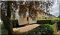
Houses of Gardendale Avenue, #61 nearest
There is an Ordnance Survey benchmark Image on black bricks on the front corner, right hand face, of the nearest house
Image: © Roger Templeman
Taken: 26 Jun 2023
0.09 miles
5
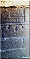
Benchmark on #61 Gardendale Avenue
Ordnance Survey cut mark benchmark levelled at 52.014m above Newlyn Datum verified 1962
Image: © Roger Templeman
Taken: 26 Jun 2023
0.10 miles
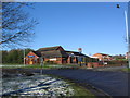
7
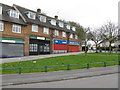
Traffic Island on A453 Near Clifton, Notts
Image: © Roy Hughes
Taken: 13 Oct 2012
0.15 miles
8
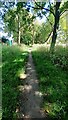
Path through woodland strip on east side of Clifton Lane near The Dip bus stop
Image: © Luke Shaw
Taken: 26 Jun 2023
0.15 miles
9
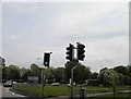
Green for go on the outskirts of Nottingham
Image: © Steve Fareham
Taken: 18 May 2012
0.16 miles
10
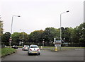
The Crusader, Clifton
Giving its name to a roundabout on the A453.
Image: © Tim Heaton
Taken: 6 Apr 2008
0.16 miles