IMAGES TAKEN NEAR TO
Linden Avenue, NOTTINGHAM, NG11 8SB
Introduction
This page details the photographs taken nearby to Linden Avenue, NG11 8SB by members of the Geograph project.
The Geograph project started in 2005 with the aim of publishing, organising and preserving representative images for every square kilometre of Great Britain, Ireland and the Isle of Man.

There are currently over 7.5m images from over14,400 individuals and you can help contribute to the project by visiting https://www.geograph.org.uk
Image Map
Images are licensed for reuse under creativecommons.org/licenses/by-sa/2.0
Notes
- Clicking on the map will re-center to the selected point.
- The higher the marker number, the further away the image location is from the centre of the postcode.
Image Listing (32 Images Found)
Images are licensed for reuse under creativecommons.org/licenses/by-sa/2.0
Image
Details
Distance
1
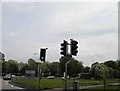
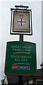
Green for go on the outskirts of Nottingham
Image: © Steve Fareham
Taken: 18 May 2012
0.05 miles
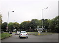
3
The Crusader, Clifton
Giving its name to a roundabout on the A453.
Image: © Tim Heaton
Taken: 6 Apr 2008
0.06 miles
4
Traffic Island on A453 Near Clifton, Notts
Image: © Roy Hughes
Taken: 13 Oct 2012
0.07 miles
7
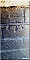
Benchmark on #61 Gardendale Avenue
Ordnance Survey cut mark benchmark levelled at 52.014m above Newlyn Datum verified 1962
Image: © Roger Templeman
Taken: 26 Jun 2023
0.13 miles
8
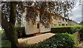
Houses of Gardendale Avenue, #61 nearest
There is an Ordnance Survey benchmark Image on black bricks on the front corner, right hand face, of the nearest house
Image: © Roger Templeman
Taken: 26 Jun 2023
0.13 miles
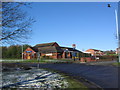
9
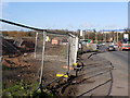
Roadworks at Clifton
Part of the widening of the A453 between Nottingham and the M1.
Image: © Alan Murray-Rust
Taken: 13 Feb 2014
0.16 miles
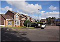
10

Housing on Hartness Road
Two contrasting styles of housing on Hartness Road, immediately to the north of the bus turning circle (see Image). This small estate, sometimes referred to as Barton Green, is effectively a later adjunct to the huge Clifton estate, from which it is separated by the A453.
Image: © Richard Vince
Taken: 23 Apr 2012
0.17 miles