IMAGES TAKEN NEAR TO
Milldale Close, NOTTINGHAM, NG11 8NU
Introduction
This page details the photographs taken nearby to Milldale Close, NG11 8NU by members of the Geograph project.
The Geograph project started in 2005 with the aim of publishing, organising and preserving representative images for every square kilometre of Great Britain, Ireland and the Isle of Man.

There are currently over 7.5m images from over14,400 individuals and you can help contribute to the project by visiting https://www.geograph.org.uk
Image Map
Images are licensed for reuse under creativecommons.org/licenses/by-sa/2.0
Notes
- Clicking on the map will re-center to the selected point.
- The higher the marker number, the further away the image location is from the centre of the postcode.
Image Listing (88 Images Found)
Images are licensed for reuse under creativecommons.org/licenses/by-sa/2.0
Image
Details
Distance
1
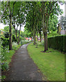
Clifton: from Village Road to Milldale Close
A tree-lined twitchel on a wet May morning.
Image: © John Sutton
Taken: 18 May 2015
0.04 miles
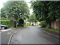
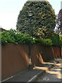
3
Village Road, Clifton
The peace of the village is preserved by its No Through Road status.
Image: © Tim Heaton
Taken: 6 Apr 2008
0.06 miles
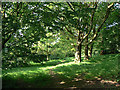
4
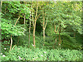
Clifton Woods
The steep scarp of Clifton Woods is populated by a mix of traditional broadleaf species, including Sycamore, Ash, Beech and Lime.
Image: © Alan Murray-Rust
Taken: 29 May 2009
0.07 miles
5
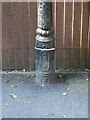
Lamppost base
The letters stand for Nottingham Corporation Lighting Department. For the complete lamp see Image
Image: © Alan Murray-Rust
Taken: 29 May 2009
0.08 miles
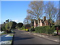
6
Cast iron lamppost
In the conservation area of Clifton Village. The base has the letters NCLD cast into the base Image
Image: © Alan Murray-Rust
Taken: 29 May 2009
0.08 miles
7
Lighting column on Holgate, Clifton
This style has replaced the previous cast iron lamps http://www.geograph.org.uk/photo/1336736 although it is not obvious why it should have been considered necessary. In my view the old ones were more in keeping with this area.
Image: © Alan Murray-Rust
Taken: 13 Feb 2014
0.08 miles
8
Clifton Grove
This is the upper level on top of the scarp and was originally planted around 1740. There are oak and chestnut trees on the level top which do not appear on the scarp down to the river.
The Grove proper is a planted avenue a bit further off to the right, but the name appears to be applied now to the whole of this wooded area to the north of Clifton Hall.
Image: © Alan Murray-Rust
Taken: 29 May 2009
0.09 miles
9
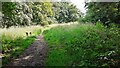
Footpath in Clifton Grove Nature Reserve
Image: © Roger Templeman
Taken: 26 Jun 2023
0.10 miles
10
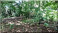
Woodland in Clifton Grove Nature Reserve
Image: © Luke Shaw
Taken: 26 Jun 2023
0.10 miles