IMAGES TAKEN NEAR TO
Nethergate, NOTTINGHAM, NG11 8NL
Introduction
This page details the photographs taken nearby to Nethergate, NG11 8NL by members of the Geograph project.
The Geograph project started in 2005 with the aim of publishing, organising and preserving representative images for every square kilometre of Great Britain, Ireland and the Isle of Man.

There are currently over 7.5m images from over14,400 individuals and you can help contribute to the project by visiting https://www.geograph.org.uk
Image Map
Images are licensed for reuse under creativecommons.org/licenses/by-sa/2.0
Notes
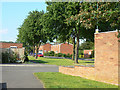
- Clicking on the map will re-center to the selected point.
- The higher the marker number, the further away the image location is from the centre of the postcode.
Image Listing (93 Images Found)
Images are licensed for reuse under creativecommons.org/licenses/by-sa/2.0
Image
Details
Distance
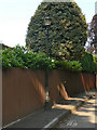
1
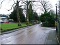
Village Road
Old Clifton looking towards the top of the cliff above the river. St. Mary's Church is left of centre partially hidden by the trees.
Image: © Mick Garratt
Taken: 22 Feb 2006
0.02 miles
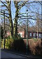
2
Nethergate
The back lane of Clifton Village, now converted to a footpath beyond the posts.
Image: © Alan Murray-Rust
Taken: 29 May 2009
0.05 miles
3
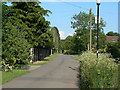
Village Road, Clifton
The peace of the village is preserved by its No Through Road status.
Image: © Tim Heaton
Taken: 6 Apr 2008
0.06 miles
4
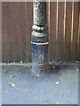
Lamppost base
The letters stand for Nottingham Corporation Lighting Department. For the complete lamp see Image
Image: © Alan Murray-Rust
Taken: 29 May 2009
0.08 miles
5
Cast iron lamppost
In the conservation area of Clifton Village. The base has the letters NCLD cast into the base Image
Image: © Alan Murray-Rust
Taken: 29 May 2009
0.08 miles
6
Lighting column on Holgate, Clifton
This style has replaced the previous cast iron lamps http://www.geograph.org.uk/photo/1336736 although it is not obvious why it should have been considered necessary. In my view the old ones were more in keeping with this area.
Image: © Alan Murray-Rust
Taken: 13 Feb 2014
0.08 miles
7
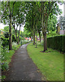
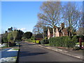
Clifton: from Village Road to Milldale Close
A tree-lined twitchel on a wet May morning.
Image: © John Sutton
Taken: 18 May 2015
0.08 miles
8
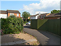
Footpath off Nethergate
Leading into the modern development of Garrett Grove, named after the nurse, Elizabeth Garret Anderson.
Image: © Alan Murray-Rust
Taken: 29 May 2009
0.08 miles
9
Gervase Close
Modern development in the heart of Clifton Village, seen from Nethergate.
Image: © Alan Murray-Rust
Taken: 29 May 2009
0.09 miles
10
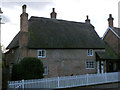
27 and 29 Village Road, Clifton
Originally built as a single house, later split but now apparently a single house again.
Basically a timber framed house dating from around 1500, with the inevitable later alterations. Some of the timber farming is exposed to the left of the left hand chimney stack. Listed Grade II.
When listed the two cottages were known as Clematis Cottage and fern Cottage, but now the name 'Hardy's Cottage' appears on the plaque in the centre of the ground floor.
Image: © Alan Murray-Rust
Taken: 13 Feb 2014
0.10 miles