IMAGES TAKEN NEAR TO
Clifton Hall Drive, NOTTINGHAM, NG11 8NJ
Introduction
This page details the photographs taken nearby to Clifton Hall Drive, NG11 8NJ by members of the Geograph project.
The Geograph project started in 2005 with the aim of publishing, organising and preserving representative images for every square kilometre of Great Britain, Ireland and the Isle of Man.

There are currently over 7.5m images from over14,400 individuals and you can help contribute to the project by visiting https://www.geograph.org.uk
Image Map
Images are licensed for reuse under creativecommons.org/licenses/by-sa/2.0
Notes
- Clicking on the map will re-center to the selected point.
- The higher the marker number, the further away the image location is from the centre of the postcode.
Image Listing (75 Images Found)
Images are licensed for reuse under creativecommons.org/licenses/by-sa/2.0
Image
Details
Distance
1
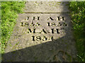
Gravestone in St Mary's churchyard
An unusually deeply carved slab, now in use to form a pathway. There is nothing to indicate who the individuals were. The closeness of the dates suggests perhaps infant mortality.
Image: © Alan Murray-Rust
Taken: 13 Feb 2014
0.06 miles
2
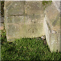
Bench mark, St Mary's Church, Clifton
See http://www.geograph.org.uk/photo/3851861 for location.
Image: © Alan Murray-Rust
Taken: 13 Feb 2014
0.06 miles
3
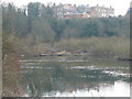
House on the hill over the river at Clifton from Beeston
Image: © Andy Jamieson
Taken: 30 Dec 2008
0.06 miles
4
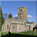
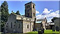
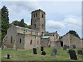
St Mary's Church, Clifton
An alternative view to http://www.geograph.org.uk/photo/1336733 with the sun more fully on the church.
The church is mainly 14th century, although the north aisle arcade dates to around 1190, and the south to around 1290. The clerestory was added in the late 14th century and it can be seen in this view that the previous roof line was much steeper; note the change in stonework in the west gable, and the surviving hood mould on the tower face.
A further item of note is the cross on the west gable. This is a rare surviving example of a pre-reformation crucifix cross. Listed Grade I.
There is a bench mark http://www.geograph.org.uk/photo/3851854 on the corner buttress of the more modern green-roofed extension to the south aisle.
Image: © Alan Murray-Rust
Taken: 13 Feb 2014
0.06 miles
6
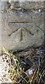
Benchmark on buttress of St Mary the Virgin Church
Ordnance Survey cut mark benchmark levelled at 46.270m above Newlyn Datum verified 1962
Image: © Roger Templeman
Taken: 26 Jun 2023
0.06 miles
7
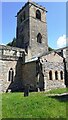
Tower of St Mary the Virgin church
There is an Ordnance Survey benchmark Image on the left hand buttress on the corner in the middle of the image
Image: © Roger Templeman
Taken: 26 Jun 2023
0.06 miles
8
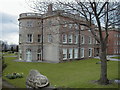
Clifton Hall, Clifton, Nottingham
A shot of the building showing the end of the building. Once part of Trent Polytechnic's School of Education
Image: © Karen Chantrey Wood
Taken: 5 Apr 2000
0.06 miles
10
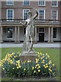
Clifton Hall's Bacchus
Even though the statues around Clifton Hall grounds were in a state of disrepair, Ted, one of the University porters, insisted on planting bulbs to brighten the place up for the students.
Image: © Karen Chantrey Wood
Taken: 5 Apr 2000
0.07 miles