IMAGES TAKEN NEAR TO
Farnborough Road, NOTTINGHAM, NG11 8JX
Introduction
This page details the photographs taken nearby to Farnborough Road, NG11 8JX by members of the Geograph project.
The Geograph project started in 2005 with the aim of publishing, organising and preserving representative images for every square kilometre of Great Britain, Ireland and the Isle of Man.

There are currently over 7.5m images from over14,400 individuals and you can help contribute to the project by visiting https://www.geograph.org.uk
Image Map
Images are licensed for reuse under creativecommons.org/licenses/by-sa/2.0
Notes
- Clicking on the map will re-center to the selected point.
- The higher the marker number, the further away the image location is from the centre of the postcode.
Image Listing (161 Images Found)
Images are licensed for reuse under creativecommons.org/licenses/by-sa/2.0
Image
Details
Distance
1
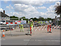
The approach to Clifton Estate
The curve onto Farnborough Road has been laid.
Image: © Alan Murray-Rust
Taken: 14 May 2014
0.04 miles
2

Tramway at Farnborough Road
The rails still stop abruptly at the end of the surfaced section.
Image: © Alan Murray-Rust
Taken: 23 Jun 2014
0.04 miles
3
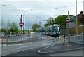
Test Tram at Farnborough Road
Regular daytime testing through to the Clifton terminus has now started. This is the entry point into Clifton Estate.
Image: © Alan Murray-Rust
Taken: 7 May 2015
0.04 miles
4
Gap in the hoarding
The tramway will curve through here to make its way across the Fairham Brook.
Image: © Alan Murray-Rust
Taken: 1 Dec 2013
0.04 miles
5
Houses under threat
This pair of houses will be the only ones to succumb to the proposed tram route to Clifton. The nearer of the pair, in the distinctive orange colour, is already unoccupied.
Image: © Alan Murray-Rust
Taken: 21 May 2009
0.04 miles
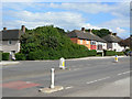
6

Brooksby Lane
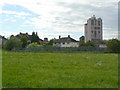
A typical road in the large Clifton Estate to the south of Nottingham. When built, in the 1950s, the estate was the largest single council estate in Europe.
Image: © Alan Murray-Rust
Taken: 21 May 2009
0.04 miles
7
Farnborough Road
Looking west towards the junction with Southchurch Drive. The proposed tram route will emerge from Southchurch Drive (beyond the white house on the left), turn towards the camera and then immediately swing to its left (to the right from this viewpoint) where the orange house can be seen far right.
Image: © Alan Murray-Rust
Taken: 21 May 2009
0.04 miles
8
The back of houses on Farnborough Road.
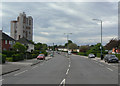
The pair of houses to the left of the picture (largely hidden by trees) will be demolished to make way for the proposed tram route to Clifton which will pass just to the right of the camera position.. Prominent is the Southchurch Court tower block.
Image: © Alan Murray-Rust
Taken: 21 May 2009
0.04 miles
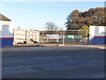
9
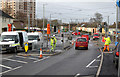
Farnborough Road junction
The layout is complete but traffic is still single lane controlled by temporary traffic lights. Work is in progress installing the permanent signals.
Image: © Alan Murray-Rust
Taken: 9 Jan 2015
0.04 miles
10
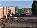
Property gone
This is the site of the one house in the Clifton area which had to be demolished. A peephole in the fence allows a view along the alignment towards Ruddington Lane.
Image: © Alan Murray-Rust
Taken: 23 Nov 2012
0.04 miles