IMAGES TAKEN NEAR TO
Colesbourne Road, NOTTINGHAM, NG11 8JG
Introduction
This page details the photographs taken nearby to Colesbourne Road, NG11 8JG by members of the Geograph project.
The Geograph project started in 2005 with the aim of publishing, organising and preserving representative images for every square kilometre of Great Britain, Ireland and the Isle of Man.

There are currently over 7.5m images from over14,400 individuals and you can help contribute to the project by visiting https://www.geograph.org.uk
Image Map
Images are licensed for reuse under creativecommons.org/licenses/by-sa/2.0
Notes
- Clicking on the map will re-center to the selected point.
- The higher the marker number, the further away the image location is from the centre of the postcode.
Image Listing (147 Images Found)
Images are licensed for reuse under creativecommons.org/licenses/by-sa/2.0
Image
Details
Distance
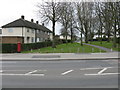
1

Farnborough Road
Looking south east from near Brooksby Road. This is the main road serving the eastern side of Clifton Estate.
Image: © Alan Murray-Rust
Taken: 21 May 2009
0.09 miles
2
Clifton - blocked access to Farnborough Road
Image: © Peter Whatley
Taken: 22 Mar 2009
0.10 miles
5
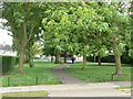
Green link
A small open space provides a pedestrian link between Southchurch Drive and Colley Moor Leys Lane.
Image: © Alan Murray-Rust
Taken: 21 May 2009
0.14 miles
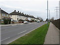
6
Southchurch Drive
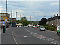
This is the main spine road of Clifton Estate. This view is looking north-east near Varney Road, showing the parade of shops serving the northern end of Clifton Estate. The proposed extension of Nottingham's tram to Clifton will run along here.
Image: © Alan Murray-Rust
Taken: 21 May 2009
0.14 miles
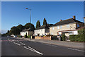
7
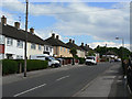
Dovenby Road
A typical road in the large Clifton Estate to the south of Nottingham. When built, in the 1950s, the estate was the largest single council estate in Europe.
Image: © Alan Murray-Rust
Taken: 21 May 2009
0.14 miles
8

Farnborough College
Originally a secondary modern school, now a technology college.
Image: © Alan Murray-Rust
Taken: 21 May 2009
0.14 miles
9
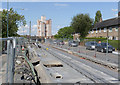
On Southchurch Drive
The section of track between Rivergreen and Farnborough Road is the longest section of street track to be laid so far. This section only needs the top surface to be laid. When done, it will be the turn of the other side of the road to be worked on.
Image: © Alan Murray-Rust
Taken: 2 Aug 2013
0.15 miles
10
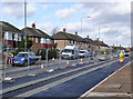
Southchurch drive near Rivergreen
This should have been reopened to traffic two weeks before the view was taken, but completion has been delayed.
Image: © Alan Murray-Rust
Taken: 13 Feb 2014
0.15 miles