IMAGES TAKEN NEAR TO
Langstrath Road, NOTTINGHAM, NG11 8BY
Introduction
This page details the photographs taken nearby to Langstrath Road, NG11 8BY by members of the Geograph project.
The Geograph project started in 2005 with the aim of publishing, organising and preserving representative images for every square kilometre of Great Britain, Ireland and the Isle of Man.

There are currently over 7.5m images from over14,400 individuals and you can help contribute to the project by visiting https://www.geograph.org.uk
Image Map
Images are licensed for reuse under creativecommons.org/licenses/by-sa/2.0
Notes
- Clicking on the map will re-center to the selected point.
- The higher the marker number, the further away the image location is from the centre of the postcode.
Image Listing (102 Images Found)
Images are licensed for reuse under creativecommons.org/licenses/by-sa/2.0
Image
Details
Distance
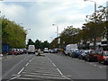
1
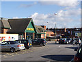
Morrisons superstore
This is the main supermarket for the large Clifton Estate.
Image: © Alan Murray-Rust
Taken: 13 Feb 2014
0.05 miles
2
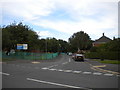
South east end of Langstrath Road, Clifton estate
Seen from Green Lane.
Image: © Richard Vince
Taken: 26 Sep 2013
0.06 miles
4
Clifton shopping centre
After 5 months, the former Woolworths store has yet to find a new occupier; the above-shop premises of the next unit are boarded up too.
Image: © Alan Murray-Rust
Taken: 21 May 2009
0.09 miles
5
Southchurch Drive at Clifton centre
Looking south towards Green Lane. This will be the location of the main tram stop for the centre of Clifton Estate.
Image: © Alan Murray-Rust
Taken: 21 May 2009
0.09 miles
6
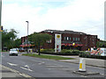
Barry Noble Social Club
Purpose-built entertainments centre on Green Lane in the centre of Clifton Estate.
Image: © Alan Murray-Rust
Taken: 21 May 2009
0.09 miles
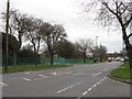
7
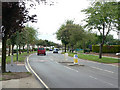
Green Lane
Looking west from near the junction with Southchurch Drive. This road marked a boundary between stages of development of the Estate.
Image: © Alan Murray-Rust
Taken: 21 May 2009
0.09 miles
8

Bench mark, Donington Road
See http://www.geograph.org.uk/photo/3851802 for location.
Image: © Alan Murray-Rust
Taken: 13 Feb 2014
0.09 miles
9
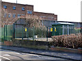
Electricity substation on Donington Road
The original building has been replaced by a modern box.
There is a bench mark http://www.geograph.org.uk/photo/3851799 at the far end of the concrete base.
Image: © Alan Murray-Rust
Taken: 13 Feb 2014
0.09 miles
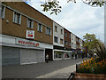
10
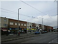
Southchurch Drive
Clifton's main shopping area.
Image: © Jonathan Thacker
Taken: 15 Feb 2022
0.10 miles