IMAGES TAKEN NEAR TO
Deane Road, NOTTINGHAM, NG11 7GD
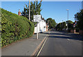
Introduction
This page details the photographs taken nearby to Deane Road, NG11 7GD by members of the Geograph project.
The Geograph project started in 2005 with the aim of publishing, organising and preserving representative images for every square kilometre of Great Britain, Ireland and the Isle of Man.

There are currently over 7.5m images from over14,400 individuals and you can help contribute to the project by visiting https://www.geograph.org.uk
Image Map
Images are licensed for reuse under creativecommons.org/licenses/by-sa/2.0
Notes
- Clicking on the map will re-center to the selected point.
- The higher the marker number, the further away the image location is from the centre of the postcode.
Image Listing (110 Images Found)
Images are licensed for reuse under creativecommons.org/licenses/by-sa/2.0
Image
Details
Distance
1
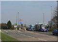
Ring Road Roundabout
Traffic coming up the A 453 and heading east towards the A52 will turn right here to get up onto the ring road.
Also of interest is one of the handful of articulated buses operated by Nottingham City Transport. Never found successful on main trunk routes - it was thought at one time that there was no future for double-deck buses, and that articulated buses were going to be necessary for their capacity - they have found their niche operating a shuttle service between the City and Clifton campuses of Nottingham trent University.
Image: © Alan Murray-Rust
Taken: 20 Mar 2009
0.06 miles
2
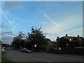
Clifton Road, Wilford
Road is currently closed ahead.
Image: © Steve Fareham
Taken: 17 Oct 2013
0.07 miles
3
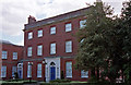
Wilford House, Clifton Lane, Nottingham
A plain red-brick Georgian house, dating from 1781 and designed by William Henderson, an architect from Loughborough. All the decoration has been reserved for the doorcase. Grade II listed.
I think it has been converted into offices.
Image: © Stephen Richards
Taken: 5 May 2003
0.08 miles
4
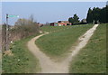
Horses to the right
The lower path is a footpath only. The bridleway turns right at the top and does not pass through the squeeze stile!
Image: © Alan Murray-Rust
Taken: 20 Mar 2009
0.09 miles
5
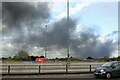
A large pall of smoke
Stretching south-eastwards from the large fire which had broken out shortly before in Lenton Industrial Estate http://www.geograph.org.uk/photo/6832713
Image: © Alan Murray-Rust
Taken: 6 May 2021
0.10 miles
7
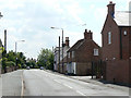
Ruddington Lane at Wilford Green
The old houses give way to general suburbia once the road gets round the bend.
Image: © Alan Murray-Rust
Taken: 29 May 2009
0.11 miles
9
Diverted bus at Wilford Green
Normally the bus service continues straight along Wilford Lane but this is currently closed for several months for the construction of the tramway crossing. The diversion adds the best part of 2 miles in each direction to the route.
Image: © Alan Murray-Rust
Taken: 13 Sep 2013
0.11 miles