IMAGES TAKEN NEAR TO
Ruddington Lane, NOTTINGHAM, NG11 7DB
Introduction
This page details the photographs taken nearby to Ruddington Lane, NG11 7DB by members of the Geograph project.
The Geograph project started in 2005 with the aim of publishing, organising and preserving representative images for every square kilometre of Great Britain, Ireland and the Isle of Man.

There are currently over 7.5m images from over14,400 individuals and you can help contribute to the project by visiting https://www.geograph.org.uk
Image Map
Images are licensed for reuse under creativecommons.org/licenses/by-sa/2.0
Notes
- Clicking on the map will re-center to the selected point.
- The higher the marker number, the further away the image location is from the centre of the postcode.
Image Listing (77 Images Found)
Images are licensed for reuse under creativecommons.org/licenses/by-sa/2.0
Image
Details
Distance
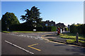
1
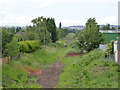
Footpath along the railway track
This will become part of the proposed tram route to Clifton. The brick construction is where industrial units have encroached on the track bed, and will have to be removed. This is roughly the location of the Ruddington Lane tram stop.
Image: © Alan Murray-Rust
Taken: 29 May 2009
0.01 miles
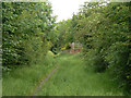
2
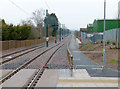
Tramway north of Ruddington Lane
Looking towards Nottingham city centre from Ruddington Lane tram stop. A combined footpath and cycleway parallels the tramway at this point.
Image: © Richard Vince
Taken: 7 Nov 2015
0.04 miles
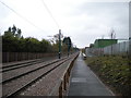
3
The railway embankment exposed
The removal of vegetation in preparation for tramway construction has opened up the view along the old railway embankment. Compare with http://www.geograph.org.uk/photo/1323359 . The Ruddington Lane tram stop will be located here, at a lower level than the existing road, which will have to be closed for a period.
Image: © Alan Murray-Rust
Taken: 1 Apr 2012
0.04 miles
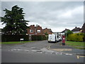
4
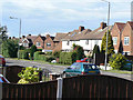
Ruddington Lane
Post-war housing along an established main road.
Image: © Alan Murray-Rust
Taken: 21 May 2009
0.04 miles
5
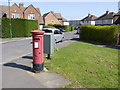
Briarfield Avenue postbox (ref. NG11 137)
A very ordinary E II R (Post Office) pillar box, resplendent in Post Office Pink. The drop box is mounted separately rather than being attached to the box. The road name-sign spells the road as Brierfield Avenue.
Image: © Alan Murray-Rust
Taken: 1 Apr 2012
0.04 miles
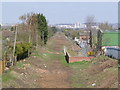
6
NET phase 2 at Ruddington Lane
Since my previous visit in April http://www.geograph.org.uk/photo/2885531 the grass has made a comeback but the next stage of work in this area is due to commence shortly. The men visible here were clearly doing some assessment work.
Image: © Alan Murray-Rust
Taken: 27 Jun 2012
0.04 miles
7
Looking north from Ruddington Lane tram stop
The foot and cycleway is essentially complete but not yet open for use between here and Wilford Lane.
Image: © Alan Murray-Rust
Taken: 11 Mar 2015
0.04 miles
8
Brierfield Avenue
Showing position of Postbox No. NG11 137.
See Image] for postbox.
Image: © JThomas
Taken: 9 Jul 2016
0.05 miles
9
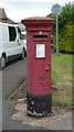
Elizabeth II postbox on Brierfield Avenue
Postbox No. NG11 137.
See Image] for context.
Image: © JThomas
Taken: 9 Jul 2016
0.05 miles