IMAGES TAKEN NEAR TO
Lamorna Grove, NOTTINGHAM, NG11 7BS
Introduction
This page details the photographs taken nearby to Lamorna Grove, NG11 7BS by members of the Geograph project.
The Geograph project started in 2005 with the aim of publishing, organising and preserving representative images for every square kilometre of Great Britain, Ireland and the Isle of Man.

There are currently over 7.5m images from over14,400 individuals and you can help contribute to the project by visiting https://www.geograph.org.uk
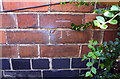
Image Map
Images are licensed for reuse under creativecommons.org/licenses/by-sa/2.0
Notes
- Clicking on the map will re-center to the selected point.
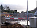
- The higher the marker number, the further away the image location is from the centre of the postcode.
Image Listing (93 Images Found)
Images are licensed for reuse under creativecommons.org/licenses/by-sa/2.0
Image
Details
Distance
1
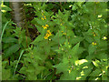
Yellow Loosestrife (Lysimachia vulgaris)
On the footpath along the old railway alignment.
Image: © Alan Murray-Rust
Taken: 29 May 2009
0.07 miles
2
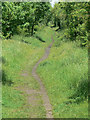
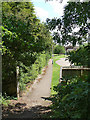
Footpath along the old railway
This will be the alignment of the proposed tram route extension to Clifton. The present embankment will be removed to allow the trams to run at ground level.
Image: © Alan Murray-Rust
Taken: 29 May 2009
0.07 miles
3
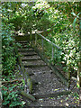
Footpath at Cranberry Close
The steps up onto the old railway embankment, which will be removed for the proposed tram route to Clifton.
Image: © Alan Murray-Rust
Taken: 29 May 2009
0.08 miles
4
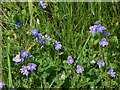
Birdseye Speedwell (Veronica chamaedrys)
On the footpath along the old railway alignment.
Image: © Alan Murray-Rust
Taken: 29 May 2009
0.09 miles
5
Footpath at Cranberry Close
Looking out from the old railway embankment.
Image: © Alan Murray-Rust
Taken: 29 May 2009
0.09 miles
6
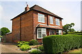
#29 Ruddington Lane
There is an OS benchmark Image on top of the ivy-clad wall about 4ft from its left hand end
Image: © Roger Templeman
Taken: 1 Jun 2018
0.09 miles
7
Benchmark on the wall of #29 Ruddington Lane
Ordnance Survey rivet benchmark levelled at 26.082m above Newlyn Datum
Image: © Roger Templeman
Taken: 1 Jun 2018
0.10 miles
8
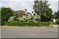
#69 Ruddington Lane
There is an OS benchmark Image on the near corner, left hand face of the house, behind a shrub
Image: © Roger Templeman
Taken: 1 Jun 2018
0.11 miles
9
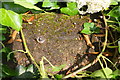
Benchmark on #69 Ruddington Lane
Ordnance Survey cut mark benchmark levelled at 25.527m above Newlyn Datum
Image: © Roger Templeman
Taken: 1 Jun 2018
0.12 miles
10
Looking south from Wilford Lane
The track in the crossing with Wilford Lane is now installed; work continues on the section southwards.
Image: © Alan Murray-Rust
Taken: 13 Jan 2014
0.12 miles