IMAGES TAKEN NEAR TO
Bradbourne Avenue, NOTTINGHAM, NG11 7BL
Introduction
This page details the photographs taken nearby to Bradbourne Avenue, NG11 7BL by members of the Geograph project.
The Geograph project started in 2005 with the aim of publishing, organising and preserving representative images for every square kilometre of Great Britain, Ireland and the Isle of Man.

There are currently over 7.5m images from over14,400 individuals and you can help contribute to the project by visiting https://www.geograph.org.uk
Image Map
Images are licensed for reuse under creativecommons.org/licenses/by-sa/2.0
Notes
- Clicking on the map will re-center to the selected point.
- The higher the marker number, the further away the image location is from the centre of the postcode.
Image Listing (46 Images Found)
Images are licensed for reuse under creativecommons.org/licenses/by-sa/2.0
Image
Details
Distance
1
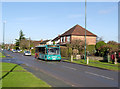
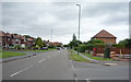
Temporary bus shuttle
Due to the closure of Ruddington Lane Image the Ruddington Connection bus service has had to be diverted. To serve the area a special shuttle service has been laid on Image
Image: © Alan Murray-Rust
Taken: 16 Dec 2012
0.07 miles
2
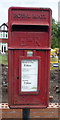
Close up, Elizabeth II postbox on Ruddington Lane
Postbox No. NG11 405.
See Image] for wider view.
Image: © JThomas
Taken: 9 Jul 2016
0.07 miles
3
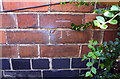
Benchmark on #69 Ruddington Lane
Ordnance Survey cut mark benchmark levelled at 25.527m above Newlyn Datum
Image: © Roger Templeman
Taken: 1 Jun 2018
0.08 miles
4
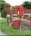
Elizabeth II postbox on Ruddington Lane
Image: © JThomas
Taken: 9 Jul 2016
0.08 miles
5
Ruddington Lane
Looking north showing position of Postbox No. NG11 405.
See Image] for postbox.
Image: © JThomas
Taken: 9 Jul 2016
0.08 miles
6
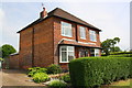
#69 Ruddington Lane
There is an OS benchmark Image on the near corner, left hand face of the house, behind a shrub
Image: © Roger Templeman
Taken: 1 Jun 2018
0.09 miles
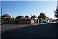
9
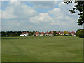
Playing fields and houses
Off Ruddington Lane.
Image: © Alan Murray-Rust
Taken: 29 May 2009
0.12 miles
10
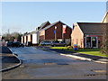
Kenny Avenue
Part of the new housing on the former Becket School site, now in the process of being occupied. The estate has the name Ruddington Place.
Image: © Alan Murray-Rust
Taken: 16 Dec 2012
0.13 miles