IMAGES TAKEN NEAR TO
Regents Place, NOTTINGHAM, NG11 7AY
Introduction
This page details the photographs taken nearby to Regents Place, NG11 7AY by members of the Geograph project.
The Geograph project started in 2005 with the aim of publishing, organising and preserving representative images for every square kilometre of Great Britain, Ireland and the Isle of Man.

There are currently over 7.5m images from over14,400 individuals and you can help contribute to the project by visiting https://www.geograph.org.uk
Image Map
Images are licensed for reuse under creativecommons.org/licenses/by-sa/2.0
Notes
- Clicking on the map will re-center to the selected point.
- The higher the marker number, the further away the image location is from the centre of the postcode.
Image Listing (101 Images Found)
Images are licensed for reuse under creativecommons.org/licenses/by-sa/2.0
Image
Details
Distance
1
Co-op at Wilford Green
A smallish supermarket, but very much the local shop.
Image: © Alan Murray-Rust
Taken: 29 May 2009
0.05 miles
2
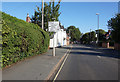
#29 Ruddington Lane
There is an OS benchmark Image on top of the ivy-clad wall about 4ft from its left hand end
Image: © Roger Templeman
Taken: 1 Jun 2018
0.05 miles
3
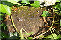
Benchmark on the wall of #29 Ruddington Lane
Ordnance Survey rivet benchmark levelled at 26.082m above Newlyn Datum
Image: © Roger Templeman
Taken: 1 Jun 2018
0.05 miles
5
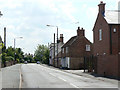
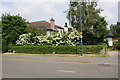
Ruddington Lane at Wilford Green
The old houses give way to general suburbia once the road gets round the bend.
Image: © Alan Murray-Rust
Taken: 29 May 2009
0.06 miles
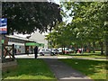
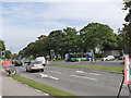
6
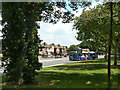
Wilford Green
The old village green alongside Wilford Lane. The articulated bus is one of five; they are used exclusively on the shuttle service between the Nottingham Trent University's City and Clifton Campuses.
Image: © Alan Murray-Rust
Taken: 29 May 2009
0.06 miles
7
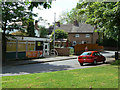
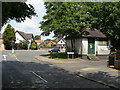
Pinfold Lane
With the local Library and some older cottages on Ruddington Lane.
Image: © Alan Murray-Rust
Taken: 29 May 2009
0.07 miles
8
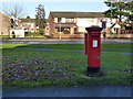
Wilford Post Office postbox NG11 408
Standard EIIR pillar box with attached drop box, on Wilford Green. The post office is some distance away.
Image: © Alan Murray-Rust
Taken: 16 Dec 2012
0.08 miles
9
Substation at Wilford Green
Built in a style that fits well with the older buildings in the neighbourhood.
Image: © Alan Murray-Rust
Taken: 29 May 2009
0.08 miles
10
Diverted bus at Wilford Green
Normally the bus service continues straight along Wilford Lane but this is currently closed for several months for the construction of the tramway crossing. The diversion adds the best part of 2 miles in each direction to the route.
Image: © Alan Murray-Rust
Taken: 13 Sep 2013
0.10 miles