IMAGES TAKEN NEAR TO
Main Road, NOTTINGHAM, NG11 7AL
Introduction
This page details the photographs taken nearby to Main Road, NG11 7AL by members of the Geograph project.
The Geograph project started in 2005 with the aim of publishing, organising and preserving representative images for every square kilometre of Great Britain, Ireland and the Isle of Man.

There are currently over 7.5m images from over14,400 individuals and you can help contribute to the project by visiting https://www.geograph.org.uk
Image Map
Images are licensed for reuse under creativecommons.org/licenses/by-sa/2.0
Notes
- Clicking on the map will re-center to the selected point.
- The higher the marker number, the further away the image location is from the centre of the postcode.
Image Listing (106 Images Found)
Images are licensed for reuse under creativecommons.org/licenses/by-sa/2.0
Image
Details
Distance
1
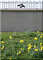
Not so busy bee
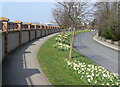
The railings along the top of this wall have a bee in each section. It is a recent construction to raise the level of protection against high water on the River Trent.
Image: © Alan Murray-Rust
Taken: 20 Mar 2009
0.04 miles
2
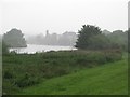
A dismal July morning
The Trent at Wilford, with the misty silhouette of the parish church just visible through the heavy rain - a picture to sum up the awful summer of 2012.
Image: © John Sutton
Taken: 19 Jul 2012
0.05 miles
3
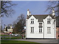
South Wilford Endowed CE VA Primary School
The 'To Let' sign is slightly misleading; it refers to this building only, not to the school as a whole. However, a building dating from 1736 is hardly suited to modern educational needs.
The tablet above the middle window reads as follows:
This School was Erected 1736 pursuant to the will of the Revd MR CARTER late Rector of this Parish who left £200 for that purpose & £50 p annum Salary for the Schoolmaster to be chosen by the Rector for the time being & £5 p annum to buy Books & other Necessarys for the School & £5 p annum to put a Scholar out Apprentice & £5 yearly to ye Poor of this Town & £400 to purchase Land for ye Augmentation of ye aforesaid Charitys . He built ye Parsonage - House Barn Stable & Dove coat. He gave a set of Communion Plate & Beautified the Chancel in his lifetime & left a sum to beautify ye Church answerable to the Chancel & bequeathed many other considerable Charitys.
He died ye 23d of December 1732 and lies buried in ye Chancel.
W.Tilly Sculpsit
Clearly the Rector was a wealthy man for those days.
Also of interest in the text of the tablet is the mixed use of p(er) annum and yearly, and also of ye and the.
Image: © Alan Murray-Rust
Taken: 20 Mar 2009
0.05 miles
4
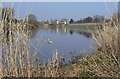
River Trent below Clifton Bridge
Water levels are relatively low for this time of year.
Image: © Alan Murray-Rust
Taken: 20 Mar 2009
0.05 miles
5
Main Road, Wilford
The wall to the left is not surrounding private land, but is part of the work to raise the level of flood protection along the River Trent.
Image: © Alan Murray-Rust
Taken: 20 Mar 2009
0.06 miles
6
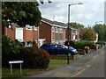
Bader Road, Wilford
Bader Road is a cul-de-sac leading off Main Road in Wilford village lined with semi-detached houses.
Image: © Stephen McKay
Taken: 9 Oct 2019
0.06 miles
7
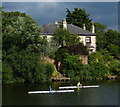
Rowers on the River Trent
The house is on the Main Road in the village of Wilford, Nottingham.
Image: © Mat Fascione
Taken: 22 Jul 2015
0.09 miles
8
Wilford across the River Trent
From the Trent Valley Way
Image: © Andrew Abbott
Taken: 25 May 2020
0.09 miles
9
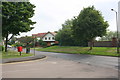
Junction of Bader Road with Main Road
Image: © Roger Templeman
Taken: 1 Jun 2018
0.09 miles
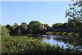
10
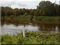
River Trent, Wilford
Seen from Main Road where the river runs past Wilford village. Note the flood height marker which looks as though it could do with replacement.
Image: © Stephen McKay
Taken: 9 Oct 2019
0.10 miles