IMAGES TAKEN NEAR TO
Coronation Avenue, NOTTINGHAM, NG11 7AB
Introduction
This page details the photographs taken nearby to Coronation Avenue, NG11 7AB by members of the Geograph project.
The Geograph project started in 2005 with the aim of publishing, organising and preserving representative images for every square kilometre of Great Britain, Ireland and the Isle of Man.

There are currently over 7.5m images from over14,400 individuals and you can help contribute to the project by visiting https://www.geograph.org.uk
Image Map
Images are licensed for reuse under creativecommons.org/licenses/by-sa/2.0
Notes
- Clicking on the map will re-center to the selected point.
- The higher the marker number, the further away the image location is from the centre of the postcode.
Image Listing (355 Images Found)
Images are licensed for reuse under creativecommons.org/licenses/by-sa/2.0
Image
Details
Distance
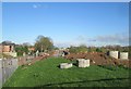
1
Flood defence wall
As part of the tramway route past Wilford Village, extra flood defence precautions have been incorporated in the tramway construction.
Image: © Alan Murray-Rust
Taken: 27 Oct 2013
0.01 miles
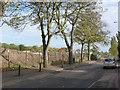
2
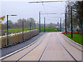
Alongside Coronation Avenue
The footway/cycleway has been opened. Concerted testing of the tramway is now imminent.
Image: © Alan Murray-Rust
Taken: 28 Nov 2014
0.01 miles
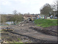
3
Alongside Coronation Avenue
The tramway drops down to the level of the road. Note the wall on the right which is a flood defence barrier.
Image: © Alan Murray-Rust
Taken: 4 Apr 2014
0.02 miles
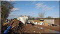
4
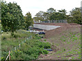
Tree clearance at Wilford
A bit more of the former railway embankment is being demolished to accommodate the tram route and to provide floodwater capacity to replace the volume lost by the repositioning of the tramway embankment.
Image: © Alan Murray-Rust
Taken: 1 Apr 2012
0.02 miles
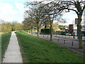
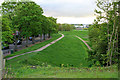
5
Coronation Avenue
The tramway will ramp down to ground level alongside Coronation Avenue.
Image: © Alan Murray-Rust
Taken: 27 Oct 2013
0.02 miles
6
Alongside Coronation Avenue
Further earthmoving has taken place in this sector. The tramway will run on top of an enlarged and realigned embankment.
Image: © Alan Murray-Rust
Taken: 30 Jan 2013
0.02 miles
7
Wilford: tramway works between Coronation Avenue and the new flood wall
Trams will runs parallel to Coronation Avenue, on the dry side of the huge new flood wall - which will be faced with coursed Bulwell stone, a real Nottingham style. Image] shows this area in September 2013.
Image: © John Sutton
Taken: 8 Feb 2014
0.02 miles
8
Coronation Avenue
The new tram route to Clifton will run along here.
Image: © Alan Murray-Rust
Taken: 7 Apr 2009
0.02 miles
9
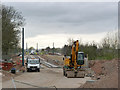
Wilford: tramway works at Coronation Avenue
Rails are about to be laid on the straight stretch between Coronation Avenue and the new flood wall. The line will curve sharply to run parallel to the old railway embankment to Wilford Lane. It will cross the riverside path just in front of the two women on the extreme left of this picture.
Image: © John Sutton
Taken: 8 Apr 2014
0.02 miles
10
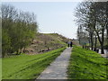
Flood bank at Iremonger Pond
The NET tram line is due to run along here. See also Image for more information.
The picture was taken from the embankment of the former Great Central Railway.
Image: © David Lally
Taken: 10 May 2012
0.02 miles