IMAGES TAKEN NEAR TO
Main Road, NOTTINGHAM, NG11 7AA
Introduction
This page details the photographs taken nearby to Main Road, NG11 7AA by members of the Geograph project.
The Geograph project started in 2005 with the aim of publishing, organising and preserving representative images for every square kilometre of Great Britain, Ireland and the Isle of Man.

There are currently over 7.5m images from over14,400 individuals and you can help contribute to the project by visiting https://www.geograph.org.uk
Image Map
Images are licensed for reuse under creativecommons.org/licenses/by-sa/2.0
Notes
- Clicking on the map will re-center to the selected point.
- The higher the marker number, the further away the image location is from the centre of the postcode.
Image Listing (281 Images Found)
Images are licensed for reuse under creativecommons.org/licenses/by-sa/2.0
Image
Details
Distance
2
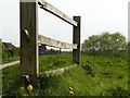
Glebe Cottages
A row of late 19th century cottages facing Wilford Green. Listed Grade II.
Image: © Alan Murray-Rust
Taken: 9 Jan 2013
0.05 miles
3
Glebe Cottages
Late 19th century, presumably built as a result of an endowment.
Image: © Alan Murray-Rust
Taken: 20 Mar 2009
0.05 miles
4
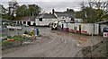
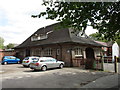
Ferry Inn
How many customers are prepared to tramp through the mud caused by the Nottingham Tram extension works? The road sweeping vehicle was making a brave effort to clean up, but only seemed to be spreading the mud more evenly.
Image: © Chris Morgan
Taken: 11 Nov 2013
0.05 miles
5
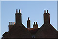
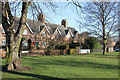
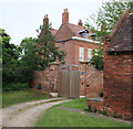
Chimney stacks at the old Wilford Rectory
The house dates from around 1720 and is Listed Grade II.
Image: © Alan Murray-Rust
Taken: 9 Jan 2013
0.05 miles
6
Wilford Rectory
Dates from about 1720 http://www.britishlistedbuildings.co.uk/en-455823-wilford-rectory-#.VUSj15PofTg
This part of Wilford still gives the impression of a village but suburbia is close at hand.
Image: © Jonathan Thacker
Taken: 1 May 2015
0.05 miles
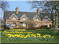
8
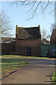
Wilford Dovecot
Built at the same time as the adjacent Rectory, c.1720. Listed Grade II. Note the mounting block at the left hand side.
Image: © Alan Murray-Rust
Taken: 9 Jan 2013
0.06 miles
9
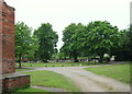
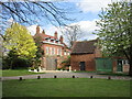
Nottingham - NG11 (Wilford Village)
A view of the 'green space' and one of the two overspill cemeteries near to St Wilfrid's Church. The original vicarage lies behind the photographer. There appears to be a mounting block at the corner of the building on the left? Also, at the 'turn' of right-hand branch of the driveway, a humped pathway leading down to the river is visible next to the end of the stone wall.
Image: © David Hallam-Jones
Taken: 2 Jun 2012
0.06 miles
10
Nottingham - NG11 (Wilford Village)
The original St Wilfrid's Church vicarage. Note the mounting block at the corner of the barn, stable or mews building.
Image: © David Hallam-Jones
Taken: 2 Jun 2012
0.06 miles