IMAGES TAKEN NEAR TO
NG11 6SJ
Introduction
This page details the photographs taken nearby to NG11 6SJ by members of the Geograph project.
The Geograph project started in 2005 with the aim of publishing, organising and preserving representative images for every square kilometre of Great Britain, Ireland and the Isle of Man.

There are currently over 7.5m images from over14,400 individuals and you can help contribute to the project by visiting https://www.geograph.org.uk
Image Map
Images are licensed for reuse under creativecommons.org/licenses/by-sa/2.0
Notes
- Clicking on the map will re-center to the selected point.
- The higher the marker number, the further away the image location is from the centre of the postcode.
Image Listing (17 Images Found)
Images are licensed for reuse under creativecommons.org/licenses/by-sa/2.0
Image
Details
Distance
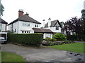
1

Ecoplant
Nursery on Flawforth Lane. This presumably supplies direct to the trade as there is no sign of public access.
Image: © Alan Murray-Rust
Taken: 21 Jun 2010
0.13 miles
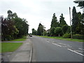
2

Flawforth Avenue
Inter-war development off Flawforth Lane.
Image: © Alan Murray-Rust
Taken: 21 Jun 2010
0.14 miles
3
Flawforth Lane
Looking west towards Ruddington.
Image: © David Lally
Taken: 5 Feb 2010
0.17 miles
4

Stile on Flawforth Lane
The footpath cuts a considerable corner off the dog-leg route of Flawforth Lane.
Image: © Alan Murray-Rust
Taken: 21 Jun 2010
0.17 miles
5
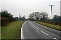
Loughborough Road (A60), Ruddington
Looking south.
Image: © JThomas
Taken: 9 Jul 2016
0.17 miles
7

Flawforth Lane
Heading east from Ruddington.
Image: © JThomas
Taken: 9 Jul 2016
0.17 miles

9
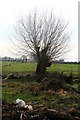
Old willow
Next to a derelict house on the eastern outskirts of Ruddington.
Image: © David Lally
Taken: 5 Feb 2010
0.18 miles
10

Ruined barn
Alongside Flawforth Lane.
Image: © Alan Murray-Rust
Taken: 21 Jun 2010
0.19 miles