IMAGES TAKEN NEAR TO
Keyworth Lane, NOTTINGHAM, NG11 6QZ
Introduction
This page details the photographs taken nearby to Keyworth Lane, NG11 6QZ by members of the Geograph project.
The Geograph project started in 2005 with the aim of publishing, organising and preserving representative images for every square kilometre of Great Britain, Ireland and the Isle of Man.

There are currently over 7.5m images from over14,400 individuals and you can help contribute to the project by visiting https://www.geograph.org.uk
Image Map
Images are licensed for reuse under creativecommons.org/licenses/by-sa/2.0
Notes
- Clicking on the map will re-center to the selected point.
- The higher the marker number, the further away the image location is from the centre of the postcode.
Image Listing (6 Images Found)
Images are licensed for reuse under creativecommons.org/licenses/by-sa/2.0
Image
Details
Distance
1
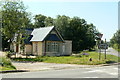
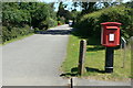
Keyworth Lane Lodge
Part of the Bunny Hall estate. The lodge has been recently extended.
Image: © Alan Murray-Rust
Taken: 21 Jun 2010
0.06 miles
2
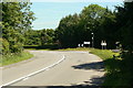
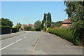
Keyworth Lane junction
The A60 Nottingham - Loughborough road at Bunny.
Image: © Alan Murray-Rust
Taken: 21 Jun 2010
0.06 miles
3
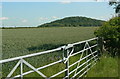
View towards Rancliffe Wood
Wheat growing in the field in the foreground.
Image: © Alan Murray-Rust
Taken: 21 Jun 2010
0.11 miles
5
Postbox Ref: HG11 172
One of the later versions of stand-alone postbox developed by the Royal Mail, but never installed in large numbers. On the corner of Albert Road and Loughborough Road in Bunny.
Image: © Alan Murray-Rust
Taken: 21 Jun 2010
0.17 miles
6
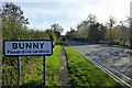
Albert Road
This and its linked road, Victoria Road, look as if a section of urban suburbia has been cut from a largely town and simply dropped into the countryside.
Image: © Alan Murray-Rust
Taken: 21 Jun 2010
0.20 miles