IMAGES TAKEN NEAR TO
Church Street, NOTTINGHAM, NG11 6QW
Introduction
This page details the photographs taken nearby to Church Street, NG11 6QW by members of the Geograph project.
The Geograph project started in 2005 with the aim of publishing, organising and preserving representative images for every square kilometre of Great Britain, Ireland and the Isle of Man.

There are currently over 7.5m images from over14,400 individuals and you can help contribute to the project by visiting https://www.geograph.org.uk
Image Map
Images are licensed for reuse under creativecommons.org/licenses/by-sa/2.0
Notes
- Clicking on the map will re-center to the selected point.
- The higher the marker number, the further away the image location is from the centre of the postcode.
Image Listing (102 Images Found)
Images are licensed for reuse under creativecommons.org/licenses/by-sa/2.0
Image
Details
Distance
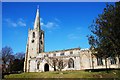
1
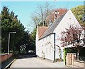
Bunny, Notts.
"The White House" on Church Street dates from 1686. Opposite its front elevation is St Mary's graveyard's northern boundary wall. Ahead Church Street becomes Moor Lane.
Image: © David Hallam-Jones
Taken: 20 Apr 2018
0.01 miles
2
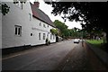
Church Street, Bunny
Interesting property alongside the church with a date of 1686 I think. Looking towards the A60.
Image: © roger geach
Taken: 25 May 2009
0.02 miles
3
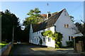
The White House
A Grade II listed building. List entry Number: 1277787 https://historicengland.org.uk/listing/the-list/list-entry/1277787
Image: © David Lally
Taken: 7 Nov 2013
0.02 miles
4
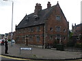
Almshouses, Bunny
Sir Thomas Parkyns funded the building of the almshouses close to the church. They were designed and built in 1700 and were for four poor widows of Bunny and the nearby Bradmore.
Image: © Richard Rogerson
Taken: 17 Sep 2010
0.02 miles
5
Bunny, Notts.
"The Village Green" on the north side of Church Street, with St Mary's Church of England Primary School beyond it.
Image: © David Hallam-Jones
Taken: 20 Apr 2018
0.02 miles
6
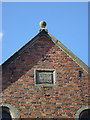
Old School House Inscription (6)
The smallest of the inscription on the building is the date stone high in the gable, lettered S(ir) T. P. with date 1700. Note the repetition of the lettering in ironwork.
For other inscriptions see http://www.geograph.org.uk/search.php?i=2644643
Image: © Alan Murray-Rust
Taken: 30 Mar 2008
0.02 miles
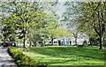
7
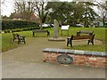
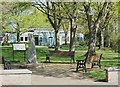
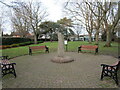
Bunny village green
Originally part of the land purchased by the County Council for the school which can be seen in the background. There was originally a farmyard on the site.
Put up for sale in 1983, it was eventually bought by the Parish Council for £3000 in 1986 for the purpose of maintaining the land as open space for the village, and developed as the village green.
Image: © Alan Murray-Rust
Taken: 20 Feb 2017
0.02 miles
8
Bunny Village Green
The village school beyond.
Image: © Jonathan Thacker
Taken: 25 Dec 2020
0.02 miles
10
Bunny, Notts.
St Mary's Church of England Primary School on Church Street. This 'green space' is designated "The Village Green".
Image: © David Hallam-Jones
Taken: 20 Apr 2018
0.02 miles