IMAGES TAKEN NEAR TO
Wysall Lane, NOTTINGHAM, NG11 6QG
Introduction
This page details the photographs taken nearby to Wysall Lane, NG11 6QG by members of the Geograph project.
The Geograph project started in 2005 with the aim of publishing, organising and preserving representative images for every square kilometre of Great Britain, Ireland and the Isle of Man.

There are currently over 7.5m images from over14,400 individuals and you can help contribute to the project by visiting https://www.geograph.org.uk
Image Map
Images are licensed for reuse under creativecommons.org/licenses/by-sa/2.0
Notes
- Clicking on the map will re-center to the selected point.
- The higher the marker number, the further away the image location is from the centre of the postcode.
Image Listing (5 Images Found)
Images are licensed for reuse under creativecommons.org/licenses/by-sa/2.0
Image
Details
Distance

3
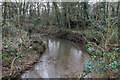
Former entrance off Wysall Lane
In the distance and straight line from the middle of the opening is the church in Bunny.
Image: © Ian S
Taken: 30 Aug 2020
0.18 miles
4
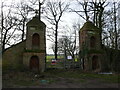
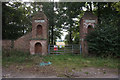
Former entrance to Bunny Park
The gatepiers and adjacent walling are listed but in generally poor condition. https://historicengland.org.uk/listing/the-list/list-entry/1277791?section=official-list-entry
Image: © Jonathan Thacker
Taken: 7 Feb 2024
0.19 miles
5
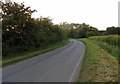
Wysall Road northwards from Wysall Road Farm
Image: © Andrew Tatlow
Taken: 21 Jun 2019
0.20 miles