IMAGES TAKEN NEAR TO
Main Street, NOTTINGHAM, NG11 6PB
Introduction
This page details the photographs taken nearby to Main Street, NG11 6PB by members of the Geograph project.
The Geograph project started in 2005 with the aim of publishing, organising and preserving representative images for every square kilometre of Great Britain, Ireland and the Isle of Man.

There are currently over 7.5m images from over14,400 individuals and you can help contribute to the project by visiting https://www.geograph.org.uk
Image Map
Images are licensed for reuse under creativecommons.org/licenses/by-sa/2.0
Notes
- Clicking on the map will re-center to the selected point.
- The higher the marker number, the further away the image location is from the centre of the postcode.
Image Listing (87 Images Found)
Images are licensed for reuse under creativecommons.org/licenses/by-sa/2.0
Image
Details
Distance
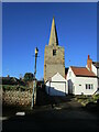
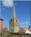
1
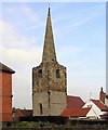
Bradmore Church
Completely hemmed-in by houses, it is impossible to photograph anything other than the C13th tower and C14th spire of this little church (here seen from the south-west). The church has had a couple of adventures..the Black Death struck whilst it was being built, and construction was halted. It was destroyed along with much of the village in a 1705 fire and lay derelict for a lengthy period (which is when the houses no doubt crept close).
Image: © Ralph Mills
Taken: 25 Jan 2006
0.02 miles
2
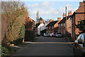
Main Street, Bradmore
This tiny village is on the west side of the A60, the main road from Nottingham to Loughborough. The majority of the houses are restored cottages and old shops and small workshops making it a highly interesting village. See Image] for more information.
Image: © Kate Jewell
Taken: 24 Jan 2008
0.03 miles
3

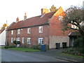
Houses on Main Street, Bradmore
What appear to be particularly bland council houses, in the centre of the village.
Image: © Richard Vince
Taken: 6 Jun 2015
0.03 miles
4
Southwell House, Bradmore
Dates from 1730 https://historicengland.org.uk/listing/the-list/list-entry/1248988?section=official-list-entry
Image: © Jonathan Thacker
Taken: 20 Jan 2023
0.04 miles
5
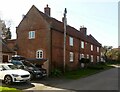
Southwell House, Main Street, Bradmore
Designed by and built for Sir Thomas Parkyns of Bunny Hall after a devastating fire in 1705 destroyed much of the village. The presence of several blocked openings suggests that at some stage it consisted of multiple dwellings. Dated 1730. Listed Grade II.
Image: © Alan Murray-Rust
Taken: 14 Mar 2022
0.04 miles
6
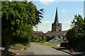
Far Street
Looking east with the church spire prominent.
Image: © Alan Murray-Rust
Taken: 21 Jun 2010
0.04 miles
7
Church tower and spire, Bradmore
The tower and spire are all that remain of a medieval chapel of ease https://historicengland.org.uk/listing/the-list/list-entry/1277785?section=official-list-entry
Image: © Jonathan Thacker
Taken: 20 Jan 2023
0.05 miles
8
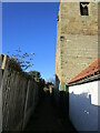
Footpath to Far Street, Bradmore
Passes the tower of Bradmore church https://historicengland.org.uk/listing/the-list/list-entry/1277785?section=official-list-entry
Image: © Jonathan Thacker
Taken: 20 Jan 2023
0.05 miles
9
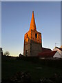
The spire at Bradmore lit by the setting sun
The tower and spire https://historicengland.org.uk/listing/the-list/list-entry/1277785?section=official-list-entry are all that remains of the medieval church at Bradmore. The rest was destroyed (together with several other buildings) by fire in 1705.
Image: © Jonathan Thacker
Taken: 20 Jan 2023
0.05 miles
10
Bradmore Church
Recreating this 'First' for the square https://www.geograph.org.uk/photo/112265
By no means the only view from this spot as it is effectively the only place where you can get a decent view of the church!
Image: © Alan Murray-Rust
Taken: 14 Mar 2022
0.05 miles