IMAGES TAKEN NEAR TO
Wayte Court, NOTTINGHAM, NG11 6NL
Introduction
This page details the photographs taken nearby to Wayte Court, NG11 6NL by members of the Geograph project.
The Geograph project started in 2005 with the aim of publishing, organising and preserving representative images for every square kilometre of Great Britain, Ireland and the Isle of Man.

There are currently over 7.5m images from over14,400 individuals and you can help contribute to the project by visiting https://www.geograph.org.uk
Image Map (Loading...)


Getting Data...Please wait
Leaflet Map data © OpenStreetMap
Images are licensed for reuse under creativecommons.org/licenses/by-sa/2.0
Notes
- Clicking on the map will re-center to the selected point.
- The higher the marker number, the further away the image location is from the centre of the postcode.
Image Listing (18 Images Found)
Images are licensed for reuse under creativecommons.org/licenses/by-sa/2.0
Image
Details
Distance
1
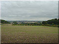
View from Spinney Hill
Looking out through the gap between Sharp Hill and Mickleborough Hill towards the Vale of Belvoir
Image: © Alan Murray-Rust
Taken: 23 Sep 2008
0.02 miles
2
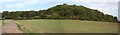
Sharphill Wood
Viewed from an access road on the eastbound carriageway of the A606. In 2006, Rushcliffe Council wanted to build 1200 new houses on this site but, after a vigorous campaign by protesters, on 15th June they decided not to go ahead.
Image: © Les Carruthers
Taken: 21 Sep 2006
0.06 miles
5
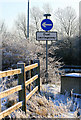
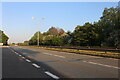
Frosty scene by the A52
-10C this morning now nearly 1 p.m and still -3.5.
Image: © David Lally
Taken: 7 Dec 2010
0.10 miles
6
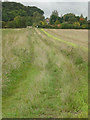
Farm track
Field access from Hall Farm.
Image: © Alan Murray-Rust
Taken: 23 Sep 2008
0.10 miles
7
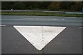
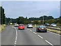
Lane Divider on a Short Road to Nowhere
http://www.geograph.org.uk/photo/1556487
Image: © David Lally
Taken: 26 Oct 2009
0.11 miles
8

Frost on a power line
Beside the A52 near Sharphill Wood.
Image: © David Lally
Taken: 7 Dec 2010
0.11 miles
9
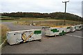
Short Road to Nowhere
Looking toward Sharphill Wood.
This must have been laid-down for a reason, but is now, as you can see, well-and-truly blocked to traffic. I would seem to have nothing to do with the, now approved, plans for a major residential Sharphill development as the site for that is on the other side of the wood.
Image: © David Lally
Taken: 26 Oct 2009
0.11 miles
