IMAGES TAKEN NEAR TO
Bunny Hall Park, NOTTINGHAM, NG11 6NE
Introduction
This page details the photographs taken nearby to Bunny Hall Park, NG11 6NE by members of the Geograph project.
The Geograph project started in 2005 with the aim of publishing, organising and preserving representative images for every square kilometre of Great Britain, Ireland and the Isle of Man.

There are currently over 7.5m images from over14,400 individuals and you can help contribute to the project by visiting https://www.geograph.org.uk
Image Map
Images are licensed for reuse under creativecommons.org/licenses/by-sa/2.0
Notes
- Clicking on the map will re-center to the selected point.
- The higher the marker number, the further away the image location is from the centre of the postcode.
Image Listing (101 Images Found)
Images are licensed for reuse under creativecommons.org/licenses/by-sa/2.0
Image
Details
Distance
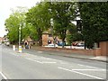
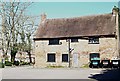
3
Rancliffe Arms, Bunny
The Rancliffe Arms is a 16th century coaching inn on Loughborough Road in this curiously-named village.
Image: © Stephen McKay
Taken: Unknown
0.06 miles

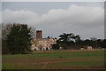
5
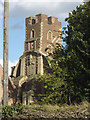
Bunny Hall - the tower
This idiosyncratic piece of architecture by the owner of the time, one of the successive Sir Thomas Parkyns, dates from around 1700. The views of it have been much restricted by a new building which can be seen creeping into the left of the picture. Better views would only be available with access into the private grounds surrounding the hall.
Image: © Alan Murray-Rust
Taken: 30 Mar 2008
0.07 miles
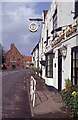
6
Bunny, Notts.
This barn-style building in The Rancliffe Arms car park has a false dovecote on its western elevation, facing the A60 Loughborough-Nottingham road. Nowadays the structure is used as a storage area by the pub tenant.
Image: © David Hallam-Jones
Taken: 20 Apr 2018
0.08 miles
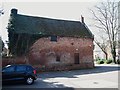
7

Former barn, Bunny
Dates from the early eighteenth century https://historicengland.org.uk/listing/the-list/list-entry/1248710 One of many buildings in the village designed by Sir Thomas Parkyns http://www.ournottinghamshire.org.uk/page_id__858_path__0p31p40p258p.aspx
Image: © Jonathan Thacker
Taken: 25 Dec 2020
0.09 miles
8
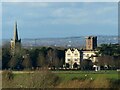
Bunny Hall and Church
Viewed from Wysall Road on Windmill Hill.
Taken from almost exactly the same viewpoint as https://www.geograph.org.uk/photo/3340502 but on a much clearer day. I was surprised just how far away some of the visible features are. The large house on the skyline 'attached' to the tower of the hall is Hopwell Hall https://www.geograph.org.uk/photo/855336 some 10 miles distant.
Image: © Alan Murray-Rust
Taken: 12 Dec 2021
0.09 miles
9
Bunny, Notts.
This barn-style building in The Rancliffe Arms car park has a false dovecote on its western elevation, facing the A60 Loughborough-Nottingham road. Nowadays the structure is used as a storage area by the pub owner or tenant.
Image: © David Hallam-Jones
Taken: 20 Apr 2018
0.09 miles
10
Bunny Hall and Tower
For picture and details of the Tower see Image
Image: © Chris
Taken: 12 Feb 2014
0.10 miles