IMAGES TAKEN NEAR TO
Wilford Road, NOTTINGHAM, NG11 6NB
Introduction
This page details the photographs taken nearby to Wilford Road, NG11 6NB by members of the Geograph project.
The Geograph project started in 2005 with the aim of publishing, organising and preserving representative images for every square kilometre of Great Britain, Ireland and the Isle of Man.

There are currently over 7.5m images from over14,400 individuals and you can help contribute to the project by visiting https://www.geograph.org.uk
Image Map
Images are licensed for reuse under creativecommons.org/licenses/by-sa/2.0
Notes
- Clicking on the map will re-center to the selected point.
- The higher the marker number, the further away the image location is from the centre of the postcode.
Image Listing (6 Images Found)
Images are licensed for reuse under creativecommons.org/licenses/by-sa/2.0
Image
Details
Distance
1
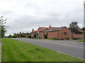
Grange Court
Former outbuildings at Grange Farm now converted into residential properties.
Image: © Alan Murray-Rust
Taken: 27 Jun 2012
0.05 miles
2
Grange Court
Former outbuildings at Grange Farm now converted into residential properties, together with some new build.
Image: © Alan Murray-Rust
Taken: 27 Jun 2012
0.05 miles
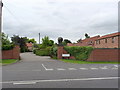
3
Grange Farm
The former farmhouse, now simply a private dwelling.
Image: © Alan Murray-Rust
Taken: 27 Jun 2012
0.07 miles
4
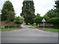
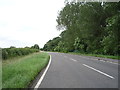
Entrance to Ruddington Grange Golf Club
Off Wilford Road.
Image: © JThomas
Taken: 9 Jul 2016
0.07 miles
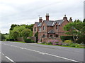
5
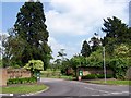
Ruddington Grange Golf Club
The golf course opened in 1988 although the Grange, a large mansion from which it takes its name, was built in 1828. http://www.ruddingtongrange.com/
Image: © Garth Newton
Taken: 4 Jun 2006
0.11 miles