IMAGES TAKEN NEAR TO
Leys Road, NOTTINGHAM, NG11 6JL
Introduction
This page details the photographs taken nearby to Leys Road, NG11 6JL by members of the Geograph project.
The Geograph project started in 2005 with the aim of publishing, organising and preserving representative images for every square kilometre of Great Britain, Ireland and the Isle of Man.

There are currently over 7.5m images from over14,400 individuals and you can help contribute to the project by visiting https://www.geograph.org.uk
Image Map
Images are licensed for reuse under creativecommons.org/licenses/by-sa/2.0
Notes
- Clicking on the map will re-center to the selected point.
- The higher the marker number, the further away the image location is from the centre of the postcode.
Image Listing (70 Images Found)
Images are licensed for reuse under creativecommons.org/licenses/by-sa/2.0
Image
Details
Distance
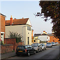
1
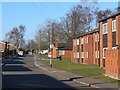
Leys Road
The housing on the right is an elderly persons' complex.
Image: © Alan Murray-Rust
Taken: 7 Mar 2010
0.03 miles
2
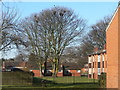
Urban rookery
This colony of rooks certainly seem to be untroubled by nesting in the middle of a housing estate.
Image: © Alan Murray-Rust
Taken: 7 Mar 2010
0.04 miles
3
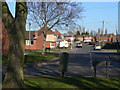
Moor Lane
Despite the name, this does not follow the line of a lane giving access onto Ruddington Moor.
Image: © Alan Murray-Rust
Taken: 7 Mar 2010
0.06 miles
4
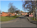
Dunblane Road
A typical street in the housing development to the south of the village centre.
Image: © Alan Murray-Rust
Taken: 7 Mar 2010
0.06 miles
5
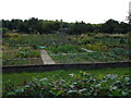
Allotments, Ruddington
Much of the north side of this road, opposite the country park, is taken up by allotments.
Image: © Oxymoron
Taken: 28 Jul 2008
0.09 miles
6
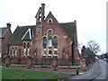
Converted school
This Victorian building in Ruddington is now offices.
Image: © Jonathan Billinger
Taken: 30 Jan 2007
0.10 miles
7
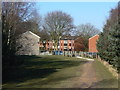
Exit from the park
The Country Park lies close to the newer residential areas of Ruddington.
Image: © Alan Murray-Rust
Taken: 7 Mar 2010
0.10 miles
8
Ruddington: frame-knitter's cottage
The circular plaque explains that the house was restored by Nottinghamshire Building Preservation Trust in 2007. For another view, see Image
Image: © John Sutton
Taken: 10 Sep 2014
0.11 miles
9
Ruddington: Top Road
Bright sunlight on a September morning. The house in the foreground is on Asher Lane.
Image: © John Sutton
Taken: 10 Sep 2014
0.11 miles
10

Ruddington: Asher Lane
The rendered building nearest the camera has first-floor framework-knitters' windows, designed to throw as much light as possible on the stocking frames. Ruddington was the largest frame knitters’ village in Nottinghamshire south of the Trent.
Image: © John Sutton
Taken: 24 Jun 2014
0.11 miles