IMAGES TAKEN NEAR TO
Rufford Road, NOTTINGHAM, NG11 6FT
Introduction
This page details the photographs taken nearby to Rufford Road, NG11 6FT by members of the Geograph project.
The Geograph project started in 2005 with the aim of publishing, organising and preserving representative images for every square kilometre of Great Britain, Ireland and the Isle of Man.

There are currently over 7.5m images from over14,400 individuals and you can help contribute to the project by visiting https://www.geograph.org.uk
Image Map
Images are licensed for reuse under creativecommons.org/licenses/by-sa/2.0
Notes
- Clicking on the map will re-center to the selected point.
- The higher the marker number, the further away the image location is from the centre of the postcode.
Image Listing (16 Images Found)
Images are licensed for reuse under creativecommons.org/licenses/by-sa/2.0
Image
Details
Distance
1
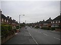
Packman Drive, Ruddington
In an area of council housing in the north east of the village.
Image: © Richard Vince
Taken: 23 Sep 2013
0.10 miles
2
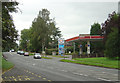
Filling station
The main Melton Road skirts the edge of Ruddington village.
Image: © Alan Murray-Rust
Taken: 23 Sep 2008
0.13 miles
3
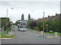
Ashworth Avenue
The north end of a mixed housing development on the north side of Ruddington. No.10 bus on its way to Nottingham. Most Nottingham City Transport buses are painted a colours specific to the route operated, but a few are painted white to allow them to be used flexibly on a variety of routes when the dedicated buses are unavailable due to maintenance or repair.
Image: © Alan Murray-Rust
Taken: 23 Sep 2008
0.15 miles
4
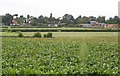
Fields and Farms near Ruddington
View from the entrance to 'The Orchard' on Flawforth Lane across fields towards Silverdale Farm and Easthorpe Farm
Image: © Les Carruthers
Taken: 21 Sep 2006
0.21 miles
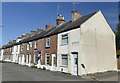
5
Savages Row, Ruddington
Parallel with Wilford Road, seen from St John's Road.
Image: © Richard Vince
Taken: 23 Sep 2013
0.22 miles
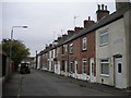
6
Savages Row
Terraced houses in Ruddington
Image: © Graham Hogg
Taken: 25 Sep 2018
0.22 miles
7
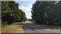
Landsmere Lane, Ruddington
Landsmere Lane is now left as a quiet route for walkers and cyclists as traffic uses a replacement adjacent road.
Image: © Peter Mackenzie
Taken: 6 Jul 2018
0.24 miles
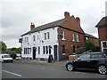
8
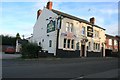
The Jolly Farmer Inn
Wilford Road, Ruddington
Image: © David Lally
Taken: 10 Oct 2008
0.24 miles
9
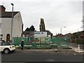
Building site on Wilford Road
The site was previously a hardware shop and residence Image
Image: © David Lally
Taken: 4 Nov 2018
0.24 miles