IMAGES TAKEN NEAR TO
Brookside Gardens, NOTTINGHAM, NG11 6AU
Introduction
This page details the photographs taken nearby to Brookside Gardens, NG11 6AU by members of the Geograph project.
The Geograph project started in 2005 with the aim of publishing, organising and preserving representative images for every square kilometre of Great Britain, Ireland and the Isle of Man.

There are currently over 7.5m images from over14,400 individuals and you can help contribute to the project by visiting https://www.geograph.org.uk
Image Map
Images are licensed for reuse under creativecommons.org/licenses/by-sa/2.0
Notes
- Clicking on the map will re-center to the selected point.
- The higher the marker number, the further away the image location is from the centre of the postcode.
Image Listing (14 Images Found)
Images are licensed for reuse under creativecommons.org/licenses/by-sa/2.0
Image
Details
Distance
1
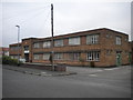
Malmic Lace Ltd factory, Ruddington (1)
The main frontage on Brookside Road.
Image: © Richard Vince
Taken: 23 Sep 2013
0.10 miles
2
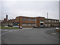
Malmic Lace Ltd factory, Ruddington (2)
Seen from Camelot Street where it meets Brookside Road (centre right). Despite the "For Sale" sign, the factory still seemed to be in use.
Image: © Richard Vince
Taken: 23 Sep 2013
0.11 miles
3
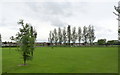
Wilford Road Recreation Ground
A small recreation ground on the northern edge of Ruddington, with football pitch.
Image: © Alan Murray-Rust
Taken: 27 Jun 2012
0.12 miles
4
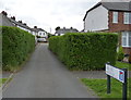
Birkin Avenue
One of a series of side streets off Wilford Road, with very narrow entries, from the inter-war period.
Image: © Alan Murray-Rust
Taken: 27 Jun 2012
0.16 miles
5
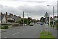
Wilford Road
Looking towards the centre of Ruddington from the edge of the built up area.
Image: © Alan Murray-Rust
Taken: 27 Jun 2012
0.17 miles
7
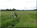
Unnamed stream near Ruddington
A tributary of the Fairham Brook which drains the area between Ruddington and Plumtree.
Image: © Alan Murray-Rust
Taken: 27 Jun 2012
0.20 miles
8
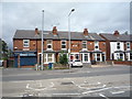
Clifton Road
With 2- and 3-storey late Victorian town houses.
Image: © Alan Murray-Rust
Taken: 7 Mar 2010
0.20 miles
9
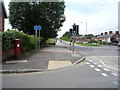
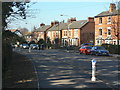
Clifton Road, Ruddington
Looking west showing position of Postbox No. NG11 301.
See Image] for postbox.
Image: © JThomas
Taken: 9 Jul 2016
0.20 miles
10
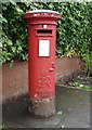
George VI postbox on Clifton Road, Ruddington
Postbox No. NG11 301.
See Image] for context.
Image: © JThomas
Taken: 9 Jul 2016
0.20 miles