IMAGES TAKEN NEAR TO
Gotham Business Park, Leake Road, NOTTINGHAM, NG11 0LB
Introduction
This page details the photographs taken nearby to Gotham Business Park, Leake Road, NG11 0LB by members of the Geograph project.
The Geograph project started in 2005 with the aim of publishing, organising and preserving representative images for every square kilometre of Great Britain, Ireland and the Isle of Man.

There are currently over 7.5m images from over14,400 individuals and you can help contribute to the project by visiting https://www.geograph.org.uk
Image Map
Images are licensed for reuse under creativecommons.org/licenses/by-sa/2.0
Notes
- Clicking on the map will re-center to the selected point.
- The higher the marker number, the further away the image location is from the centre of the postcode.
Image Listing (10 Images Found)
Images are licensed for reuse under creativecommons.org/licenses/by-sa/2.0
Image
Details
Distance
1
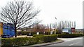
Gotham Business Park
Every night lorry loads of pallets converge on this site, which was once a Gypsum factory.
Image: © Chris J Dixon
Taken: 17 Apr 2005
0.06 miles
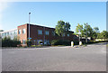
4
Gypsum Way
A relief road around the south east of Gotham. The name suggests it was built largely to remove traffic of the nearby Gypsum mine and factory from the village.
The tip of the chimney of Ratcliffe-on-Soar power station is visible toward the right.
Image: © David Lally
Taken: 18 Apr 2014
0.13 miles
5

Power Line Strides Through a Rape Field
Looking ESE from Gotham
Image: © Chris J Dixon
Taken: 17 Apr 2005
0.18 miles
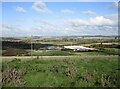
6
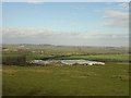
The view from West Leake Hills
The industrial premises are a transport depot but were previously a gypsum works. The flat area beyond are the fen-like Gotham and Ruddington Moors - very fertile arable land. The prominent hedge sweeping right from the left hand edge of the depot marks the line of the former Great Central Railway branch to Gotham. Although Gotham boasted a station, this handled goods traffic only and the line was never open to passengers. The principal freight was gypsum, although general goods including agricultural produce were handled as well.
Image: © Alan Murray-Rust
Taken: 21 Mar 2008
0.20 miles
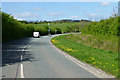
8
Gypsum Way, Gotham
This road, constructed to enable lorries to avoid Gotham village when travelling to and from the gypsum works, was built on the formation of a railway line that once served a gypsum mine to the west of the village.
Image: © Richard Vince
Taken: 15 Nov 2014
0.22 miles
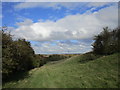
10
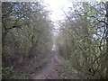
Bridleway through the trees south of Gotham
Image: © Richard Vince
Taken: 15 Nov 2014
0.23 miles