IMAGES TAKEN NEAR TO
Tomlinson Avenue, NOTTINGHAM, NG11 0JU
Introduction
This page details the photographs taken nearby to Tomlinson Avenue, NG11 0JU by members of the Geograph project.
The Geograph project started in 2005 with the aim of publishing, organising and preserving representative images for every square kilometre of Great Britain, Ireland and the Isle of Man.

There are currently over 7.5m images from over14,400 individuals and you can help contribute to the project by visiting https://www.geograph.org.uk
Image Map
Images are licensed for reuse under creativecommons.org/licenses/by-sa/2.0
Notes
- Clicking on the map will re-center to the selected point.
- The higher the marker number, the further away the image location is from the centre of the postcode.
Image Listing (122 Images Found)
Images are licensed for reuse under creativecommons.org/licenses/by-sa/2.0
Image
Details
Distance
1
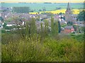
The old board school in Gotham
Building was completed in 1879 but directly across the road there is now a new primary school to serve the village.
Image: © Neil Theasby
Taken: 22 Sep 2021
0.04 miles
2
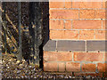
Bench mark, Gotham old Primary School
See http://www.geograph.org.uk/photo/3838602 for location.
Image: © Alan Murray-Rust
Taken: 3 Feb 2014
0.05 miles
3
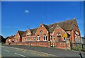
Gotham Board Schools, Kegworth Road
Replaced in 2006 by a modern school on the opposite side of the road, the old school has been refurbished and is awaiting occupancy as a single 5 bedroom residence. The building dates from 1879 when it cost £3517, and is Listed Grade II.
There is a bench mark http://www.geograph.org.uk/photo/3838608 on the near corner of the façade.
Image: © Alan Murray-Rust
Taken: 3 Feb 2014
0.05 miles
4
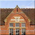
Gotham Board Schools, Kegworth Road
The central gable with inscription. The word Gotham originally appeared above the shield but was removed during World War II for anonymity in the event of invasion. See http://www.geograph.org.uk/photo/3838602
Image: © Alan Murray-Rust
Taken: 3 Feb 2014
0.05 miles
5
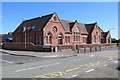
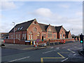
Gotham: former Board School
One of many schools built by local school boards in the years after the Forster Education Act of 1870. A new primary school is behind the camera.
Image: © John Sutton
Taken: 27 Jun 2018
0.05 miles
6
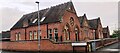
Gotham School, Kegworth Road
There is an Ordnance Survey benchmark Image on the near corner, right hand face, of the school.
Image: © Roger Templeman
Taken: 25 May 2022
0.05 miles
7
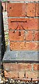
Benchmark on Gotham Primary School
Ordnance Survey cut mark benchmark levelled at 38.237m above Newlyn Datum verified 1966
Image: © Roger Templeman
Taken: 25 May 2022
0.05 miles
8
Gotham: Kegworth Road to Gotham Hill
This is where, until the early 1960s, a goods-only branch railway crossed Kegworth Road and curved away to the right - see Image] for where it ended in some sidings.
Image: © John Sutton
Taken: 27 Jun 2018
0.07 miles
9
Gotham East Leake road by the Cuckoo bush
Image: © Andy Jamieson
Taken: 20 Apr 2009
0.10 miles