IMAGES TAKEN NEAR TO
The Rushes, NOTTINGHAM, NG11 0HY
Introduction
This page details the photographs taken nearby to The Rushes, NG11 0HY by members of the Geograph project.
The Geograph project started in 2005 with the aim of publishing, organising and preserving representative images for every square kilometre of Great Britain, Ireland and the Isle of Man.

There are currently over 7.5m images from over14,400 individuals and you can help contribute to the project by visiting https://www.geograph.org.uk
Image Map
Images are licensed for reuse under creativecommons.org/licenses/by-sa/2.0
Notes
- Clicking on the map will re-center to the selected point.
- The higher the marker number, the further away the image location is from the centre of the postcode.
Image Listing (150 Images Found)
Images are licensed for reuse under creativecommons.org/licenses/by-sa/2.0
Image
Details
Distance
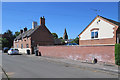
1
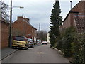
The Rushes
One of the older back streets in the village.
Image: © Alan Murray-Rust
Taken: 23 Mar 2010
0.02 miles
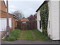
3
Paradise Farm
Former farm buildings now in residential use.
Image: © Alan Murray-Rust
Taken: 23 Mar 2010
0.04 miles
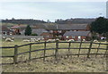
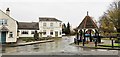
5
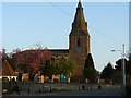
Gotham: along Malt Street
The steeple of St Lawrence's Church shows in the distance.
Image: © John Sutton
Taken: 27 Jun 2018
0.06 miles
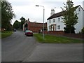
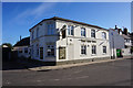
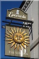
6
The Sun Inn, Gotham
No sun on this day!
Image: © Chris Morgan
Taken: 25 Nov 2019
0.07 miles
10
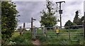
Stile for footpath off Moor Lane
Ordnance Survey documents indicate that a benchmark was levelled in 1966 at 34.127m above Newlyn Datum on a stone at the junction of the stile and a fence
Image: © Roger Templeman
Taken: 25 May 2022
0.07 miles