IMAGES TAKEN NEAR TO
West Leake Lane, NOTTINGHAM, NG11 0DN
Introduction
This page details the photographs taken nearby to West Leake Lane, NG11 0DN by members of the Geograph project.
The Geograph project started in 2005 with the aim of publishing, organising and preserving representative images for every square kilometre of Great Britain, Ireland and the Isle of Man.

There are currently over 7.5m images from over14,400 individuals and you can help contribute to the project by visiting https://www.geograph.org.uk
Image Map
Images are licensed for reuse under creativecommons.org/licenses/by-sa/2.0
Notes
- Clicking on the map will re-center to the selected point.
- The higher the marker number, the further away the image location is from the centre of the postcode.
Image Listing (19 Images Found)
Images are licensed for reuse under creativecommons.org/licenses/by-sa/2.0
Image
Details
Distance

2
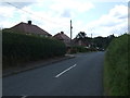
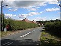
New Kingston
New Kingston is a cluster of semi-detached houses on West Leake Lane.
Image: © Malcolm Neal
Taken: 19 Aug 2021
0.03 miles
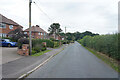
4
West Leake Lane, New Kingston
Heading south.
Image: © JThomas
Taken: 21 Jun 2014
0.10 miles
5

The route of the Kingston Mineral Railway
The Kingston Mineral Railway was built in 1883 to link Kingston Gypsum Mine to a wharf on the River Soar. A branch was added later to connect to the railway at Kegworth. The railway closed in the spring of 1971 and the rails were lifted by 1972.
Image: © Ian Calderwood
Taken: 7 May 2016
0.10 miles
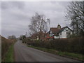
6
West Leake Lane, New Kingston (2)
Looking towards West Leake from the junction with Gotham Road and Kegworth Road.
Image: © Richard Vince
Taken: 11 Jul 2020
0.11 miles
7
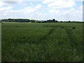
Crop field New Kingston
West of West Leake Lane.
Image: © JThomas
Taken: 21 Jun 2014
0.12 miles
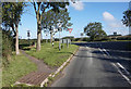
8
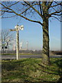
New Kingston Cross Roads
This still sports a traditional wooden armed fingerpost, although one direction is entirely missing and another substantially rotted away. In the distance can be seen Ratcliffe on Soar Power Station.
Image: © Alan Murray-Rust
Taken: 10 Feb 2008
0.12 miles
9
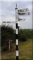
Direction Sign ? Signpost
Located on the southwest side of New Kingston crossroads in Kingston on Soar parish. 5 arms and annulus finial. A replacement for NT_SK5128 http://www.geograph.org.uk/photo/687386 which was on the southeast side of the crossroads.
Milestone Society National ID: NT_SK5128A
Image: © S Penhallurick
Taken: 22 Sep 2019
0.13 miles