IMAGES TAKEN NEAR TO
Little Lunnon, NOTTINGHAM, NG11 0AJ
Introduction
This page details the photographs taken nearby to Little Lunnon, NG11 0AJ by members of the Geograph project.
The Geograph project started in 2005 with the aim of publishing, organising and preserving representative images for every square kilometre of Great Britain, Ireland and the Isle of Man.

There are currently over 7.5m images from over14,400 individuals and you can help contribute to the project by visiting https://www.geograph.org.uk
Image Map
Images are licensed for reuse under creativecommons.org/licenses/by-sa/2.0
Notes
- Clicking on the map will re-center to the selected point.
- The higher the marker number, the further away the image location is from the centre of the postcode.
Image Listing (58 Images Found)
Images are licensed for reuse under creativecommons.org/licenses/by-sa/2.0
Image
Details
Distance
1
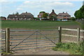
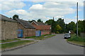
Little Lunnon
A mixed development of Local Authority and private housing on the south side of Barton. I wondered at the origin of the name, possibly a corruption of London, or maybe a variation of the word Lonnen for a lane, although this is not normally associated with the East Midlands. Older OS maps do in fact show the area as Little London.
Image: © Alan Murray-Rust
Taken: 28 May 2010
0.01 miles
2
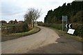
Along Manor Road
Toward the village of Barton-in-Fabis. The sign by the chevron is a sign-of-the-times; It is from Nottinghamshire Police and reads
"POLICE OPERATION IN PROGRESS
PLEASE EXCUSE ANY INCONVENIENCE THIS MIGHT CAUSE"
In the village there was one car and one van, both empty and no sign of any officers.
Image: © David Lally
Taken: 23 Feb 2010
0.03 miles
3
Road sign - children
This is a nice cast iron sign, but on close inspection appears to be a modern copy of a pre-Worboys sign.
Image: © Alan Murray-Rust
Taken: 28 May 2010
0.04 miles
4
Bus stops, Barton in Fabis
Close to the southern edge of the village, these were the only bus stops I saw in Barton. They are currently served route 865, an infrequent Nottinghamshire County Council sponsored service that connects a number of south Notts villages to commercial bus routes in Clifton and Kegworth.
Image: © Richard Vince
Taken: 25 Feb 2015
0.05 miles
6
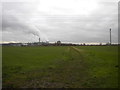
Bridleway across field south west of Barton in Fabis
This public bridleway crosses the fields to Thrumpton, becoming a mere public footpath about of a third of the way there for some reason. Inevitably, Ratcliffe on Soar power station is visible on the horizon, the water vapour from its cooling towers blending in with the clouds on this overcast day.
Image: © Richard Vince
Taken: 25 Feb 2015
0.06 miles
7
Interesting shadow
A disintegrating post casts an eagle-shaped shadow on a barn wall in Barton-in-Fabis.
Image: © David Lally
Taken: 4 Aug 2010
0.07 miles
8
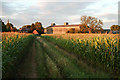
Bridleway to Thrumpton
This leaves the village of Barton through the farmyard of Top Yard.
Image: © Alan Murray-Rust
Taken: 28 May 2010
0.07 miles
9
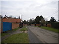
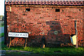
Top Yard
Originally part of Old Farm, and the part still in commercial use.
Image: © Alan Murray-Rust
Taken: 28 May 2010
0.07 miles
10
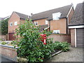
House on Manor Road, Barton in Fabis
Showing position of Postbox No. NG11 244.
See Image] for postbox.
Image: © JThomas
Taken: 9 Jul 2016
0.09 miles